
Super User

The Mississippi-Rideau Drinking Water Source Protection (MRDWSP) staff will be meeting with land and business owners this summer in the communities of Almonte, Kemptville, Merrickville, Montague, Smiths Falls and Westport who may be using chemicals that could pose a risk to the municipal drinking water systems.The Mississippi-Rideau Drinking Water Source Protection (MRDWSP) staff will be meeting with land and business owners this summer in the communities of Almonte, Kemptville, Merrickville, Montague, Smiths Falls and Westport who may be using chemicals that could pose a risk to the municipal drinking water systems.
This work is being done by MRDWSP staff on behalf of the local municipalities as they strive to meet the requirements of the Ontario’s Clean Water Act. The locally produced and supported Source Water Protection Plan sets out ways to ensure long-term protection of municipal drinking water supplies. Drinking Water Protection Zones are outlined in the Mississippi-Rideau Source Protection Plan and are areas where the drinking water source is more vulnerable and as a result has special protection.
Certain activities that take place within these zones can pose a risk to the municipal drinking water supply. Chemicals known as dense non-aqueous phase liquids (DNAPLs) are heavier than water, meaning that they sink and do not dissolve in water. These chemicals are harmful to human health and are very difficult and expensive to clean up. DNAPLs may be present in dry cleaning chemicals, paints, paint strippers, degreasing and cleaning agents, lubricants and adhesives. If these chemicals are present, Mississippi-Rideau Staff will work with land and business owners to ensure that proper practices are established and recognized so that current activities do not pose a threat to the drinking water source.
MRDWSP staff will also endeavour to meet with municipal councils prior to starting their work in each of the six communities to outline provincial requirements and the value of these outreach projects to the long-term protection of local drinking water resources.
The Mississippi-Rideau Source Protection Region is made up of the Mississippi Valley and Rideau Valley watersheds. The Source Protection Committee and staff are supported by the Mississippi Valley Conservation Authority and Rideau Valley Conservation Authority.
For more information about Mississippi-Rideau Source Water Protection and Drinking Water Protection Zones visit mrsourcewater.ca.
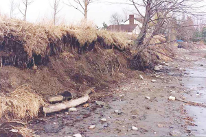
Recent high waters have caused erosion damage and damage to shoreline structures, particularly east of Cumberland along the Ottawa River and in the upper reaches (Tay Valley Watershed) of the Rideau Valley Watershed.
The Rideau Valley Conservation Authority (RVCA) recognizes that some of the remedies for damage may need more than just a minor “tweak.”
This is a reminder to all landowners to check with your local Conservation Authority to see if approval is required prior to doing any “clean-up” work along your shoreline (e.g., shoreline stabilization or repair to shore works, erosion control, dock construction, etc.). There are also restrictions to when you can undertake in-water work and possibly other approval agencies that require consulting depending on where you are in the watershed (e.g., Parks Canada and Ministry of Natural Resources and Forests).
The best thing to do is contact your local Conservation Authority to see if there are any restrictions or approval requirements. In the Rideau Watershed, call the RVCA’s Resource Specialists at 613-692-3571 or 1-800-267-3504 ext. 1128 and 1132. You can also visit the RVCA website at www.rvca.ca and look for the “After the Flood” link. Be sure to read the document entitled Guidelines for Shore Works in the Rideau Valley Watershed to help you with your project. In cases of severe erosion, funding may be available through Rural Clean Water Grants. RVCA Resource Specialists can guide you towards next steps required to make application to receive funding. Information on these grants is also available on the RVCA website.
The riparian zone (the area along the shores of our creeks, rivers and lakes) is an important area for wildlife and water quality. Trees and shrubs along the riparian zone provide a vegetative bu er that provides shelter and food for wildlife while intercepting upland nutrients. Trees and shrubs also provide valuable erosion protection. They are extremely resilient. Don’t be too quick to remove shoreline plants. Instead, give damaged plants the opportunity to respond with natural regrowth. Corrective pruning may suffice. If you are interested in naturalizing your shoreline, contact the RVCA for details on their Shoreline Naturalization Program or visit the website.
Waterfront property owners will want to remove any fallen branches and debris from their shoreline to ensure the unaltered and uninterrupted ow of water. Be sure not to dispose of garbage, debris or sandbags in the river. Check with your local municipality for local disposal options.
After the Flood: Clean-up Resources
The flood water may be gone, but it's left a lot of work in its wake. From sandbag and garbage disposal to septic inspection and well water testing, the RVCA is here to answer your questions and to help as much as possible.
1. What should I do with my sandbags?
DO NOT dump sandbags into the nearby waterway – it could make you and your neighbours sick. If sandbags have come in contact with flood water, they could be contaminated with all sorts of nasty materials, including raw sewage. They need to be disposed of properly – contact your local municipality for area-specific instructions.
Remember: Use gloves when handling used sandbags and take care not to let them spill onto roads, municipal drains or into waterways. For more information, check out this RVCA fact sheet: Cleaning Up After the Flood: Resources
2 . How do I know my well water is safe to drink?
Flooded wells need to be disinfected and tested before residents use them again. All residents on wells affected by the flood should disinfect their wells with a chlorine solution and then flush before testing. To learn more about disinfecting your well, sampling your well, and interpreting your sample results visit Ottawa Public Health’s well water information page.
3. What should I do if my septic system was flooded?
Do not use the system while the drain field or tanks are under water. Wait until the water level in the drain field is below the distribution pipes before using. If a system MUST be used, conserve water as much as possible to allow the system to restore itself.
Do not pump your septic tank during or immediately after the flood. This could cause the tank to “pop out” of the ground. Avoid using heavy machinery around the system when the ground is saturated to avoid further damage.
If you suspect damage, get a licensed inspection! If repairs are needed, contact the Ottawa Septic System Office or your local approval agency before undertaking any work.
Remember: flood waters may be contaminated with raw sewage. Wear protective gloves, eyewear, a face mask and rubber boots when in contact with the water.
For more information, check out: RVCA Factsheet: Frequently Asked Questions of the Conservation Authority and the Ottawa Septic System Office
4. I need to start repairing or rebuilding my home. What approvals do I need?
Check with your local municipality and conservation authority before beginning any repair work to see if a permit is required. Minor repairs like replacing flooring and drywall likely won’t require a permit, but larger projects like work on your foundation, outer walls or deck, or any other structural changes, will require approvals.
Landscaping work like grading, repairing shoreline retaining walls or docks will also need permits, as well as any work to secondary buildings.
For more permit information, visit: https://www.rvca.ca/regulations-planning/rvca-permits-section-28/do-i-need-a-permit
You can also contact an RVCA Resource Specialist at or 613-692-3571 ext. 1132 or ext. 1193.
Other things to consider:
-
- Have you suffered severe erosion on your shoreline? The Rural Clean Water Program (RCWP) is accepting applications for grants. Be sure to have all approvals for work in place (see above) and register with staff prior to starting work (613-692-3571 or 1-800-267-3504 ext. 1134). Permits may be required.
-
- Interested in creating a low-cost, natural shoreline along your waterfront to help fight erosion and future flooding? Learn about RVCA's Shoreline Naturalization Program.
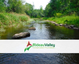
Rideau Valley Conservation Foundation Achieves Accreditation from Imagine Canada’s Standard Program

The Rideau Valley Conservation Foundation (RVCF) is pleased to announce that it has been accredited under Imagine Canada’s national Standards Program. With this achievement, RVCF joins a growing community of organizations dedicated to operational excellence. Just over 220 out of the more than 85,000 registered charities in Canada have earned the accreditation.
Designed to strengthen public confidence in the charitable and non-profit sector, the program sets rigorous criteria that require organizations to demonstrate excellence in board governance, financial accountability and transparency, ethical fundraising, staff management and volunteer involvement.
RVCF engaged in a two-year accreditation process and clearly demonstrated that its policy and procedures are transparent and thorough — meeting Imagine Canada’s country-wide set of shared standards.
“We are extremely proud of this achievement,” said Jason Kelly, RVCF Chair. “It is a strict and uncompromising process, but one that builds public trust and provides our supporters confidence in our charitable work. Our board and staff are committed to meeting the highest standards of trust.”
The Rideau Valley Conservation Foundation is a registered environmental charity working to help protect and conserve the lands and waters of the valley of the Rideau River in Eastern Ontario. The Conservation Foundation builds partnerships and seeks new individuals, corporations and groups wanting to get involved in the vital work of taking care of our own natural environment.
“It’s no small feat for an organization to earn Standards Program accreditation,” says Bruce MacDonald, President and CEO of Imagine Canada. “It’s a rigorous, peer-reviewed process that is meant to build public trust and confidence in the charitable sector. These organizations take accountability and operational transparency very seriously. We’re glad to have them on board.”
Imagine Canada is a national charitable organization whose cause is Canada’s charities. Their three broad goals are to strengthen the sector’s collective voice, create opportunities to connect and learn from each other and build the sector’s capacity to succeed.
Flood Watch Terminated For Rideau Watershed
Rain forecast for Sunday and Monday can be expected to cause levels throughout the watershed to turn upward; however, no flooding is expected.
Rain, possibly 20 to 25 millimetres, can be expected to raise levels in watershed rivers and lakes but not to flood stage similar to what occurred last weekend. Level and flow increases are expected to last for two or three days before returning to gradual declines toward long term averages.
With water levels declining and no flooding expected, the Flood Watch, maintained over the last week for the Tay River, is terminated. Conservation Authority staff will continue to monitor conditions and communicate as conditions warrant
We are still encouraging the public to tag us or share photos of water conditions in their area at RVCA Facebook (RideauValleyConservationAuthority) and Twitter (@RideauValleyCA).
For water level and flow information in the Rideau system as well as the Ottawa River, visit the RVCA Streamflows and Water Levels webpage at http://his.rvca.ca/rvcafwl/.
For more information about conditions on the Ottawa River, also check the webpage of the Ottawa River Regulation Planning Board at http://ottawariver.ca/river-levels-flows.php#river-levels-flows-7-days.
RVCA Watershed Conditions Statements:
- Water Safety – High flows, unstable banks, melting ice or other factors that could be dangerous for recreational users such as anglers, canoeists, hikers, children, pets, etc. Flooding is not expected.
- Flood Outlook – Early notice of the potential for flooding based on weather forecasts, calling for heavy rain, snow melt, high winds or other conditions that could lead to high runoff, cause ice jams and/or lakeshore flooding or erosion.
- Flood Watch – Flooding is possible in specific watercourses or municipalities. Municipalities, emergency services and individuals in flood prone areas should prepare.
- Flood Warning – Flooding is imminent or already occurring in area watercourses.

Identifying hazard lands is an important responsibility for Ontario’s Conservation Authorities.
During the last five years, the Rideau Valley Conservation Authority (RVCA) has been conducting several hazard mapping studies on watercourses within the City of Ottawa and the RVCA area of jurisdiction. For some watercourses, old mapping will be updated; and for others, hazards maps will be created for the first time.
Studies look at identifying two main types of hazards along the watercourses: flood risk and slope stability risk.
Flood risk studies make use of contemporary methods in hydrologic and hydraulic analysis,all the available historical records of streamflow and/or water level, and the most up-to-date topographical data to produce estimates of the 1:100 year flood discharge and corresponding water surface elevations and flood lines for the watercourses under consideration. The resulting flood risk maps identify areas along the river that are vulnerable to flooding, and where new development is to be restricted or prohibited in accordance with Provincial Planning Policies.
These studies are being done through a collaboration involving the City of Ottawa and the Rideau Valley, Mississippi Valley and South Nation Conservation Authorities. The City recognized a need to update its zoning schedules based on up-to-date flood risk mapping, and has provided contributions enabling the Conservation Authorities to move ahead with these studies sooner than would otherwise be possible.
Slope stability studies make use of new, highly detailed topographic data to identify toe and top of slope. This information is used to create an allowance area that serve as a flag of potentially unstable slope areas.
When completed, the new flood risk mapping will be used by the City of Ottawa when updating its Official Plan and Zoning Schedules and in the review of development applications under the Planning Act. Conservation Authorities will use the same mapping flood risk mapping as well as slope stability risk in the administration and enforcement of regulations made under the Conservation Authorities Act.
Currently, the RVCA is focusing its efforts on the following streams:
- Flowing Creek (Flewellyn Road to Jock River)
- Hobbs Drain (Fallowfield Road to Jock River)
- Kings Creek (Brunton Side Road to Jock River)
- Nichols Creek (Montague Boundary Road to Jock River)
- Becketts Creek (Sarsfield Road to Ottawa River)
- Bilberry Creek (Innes Road to Ottawa River)
- Rideau River (Hogs Back to Kars)
- Rideau River (Kars to Burritts Rapids)
Historical records, news clippings, photographs and local anecdotal stories and memories of past flood events can be useful in confirming the reasonableness of the calculations and resulting floodplain mapping. Local residents with this kind of information are encouraged to share their information and knowledge with RVCA’s Ferdous Ahmed (1-800-267-3504 or 613-692-3571 ext. 1170 or ).
Those interested in learning more about the project or being included on our contact list are also encouraged to contact the RVCA.
Once the technical work for individual study areas is complete and hazard mapping has been prepared, a public information session will be held to collect public feedback. Any new information or comments will be taken into consideration in further refinement of the mapped hazard limits.
As part of the continuing commitment to support the community and improve its already environmentally friendly operations, Carleton Refrigeration, Heating and Air Conditioning Inc. will be planting 1,302 young, vigorous, native-Canadian trees in Ottawa. The company is the newest participant in Rideau Valley Conservation Foundation’s (RVCF) Carbon Neutral Program.
Carleton Refrigeration, Heating and Air Conditioning is working with RVCF to calculate the amount of carbon emissions they produce (in tonnes of carbon dioxide) and then convert that into the number of trees to be planted to offset (or absorb) the carbon the company produces in their day-to-day operations.
Each of Carleton Refrigeration, Heating and Air Conditioning’s trees is a little environmental cleaning station producing better air, cleaner water, more wildlife habitat, noise and wind buffers, increased forest cover. Research shows that lives are improved by trees, hospital recovery times are shortened and other common problems, such as stress and attention deficit disorder, become more manageable when we are in regular contact with trees and green spaces.
Carleton Refrigeration, Heating and Air Conditioning joins a number of distinguished local companies, and many community and family events around town taking a bite out of carbon emissions and creating cleaner air for the residents of this area.
Carleton Refrigeration, Heating and Air Conditioning Ltd. is a locally owned and operated family business since 1973. Their team of dedicated professionals pride themselves on their award-winning commitment to excellence in customer service. They sell and install quality furnace and air conditioning equipment produced by superior quality manufacturers, and backed up by some of the best warranty programs in the industry.
Rideau Valley Conservation Foundation is a registered environmental charity working to improve the lands and waters of the Rideau River right here at home in Eastern Ontario. They are proud to be associated with Carleton Refrigeration, Heating and Air Conditioning Inc.
Flood Warning Withdrawn for Lakes on Tay River
Water levels are finally receding on Christie and Bobs Lakes both of which have had high water since the two bouts of heavy rain three weeks ago.
Bobs Lake levels were high from the spring runoff in April. The rain recorded at Bolingbroke, about 90 millimetres over the four days from May 4 through 7, was similar to what fell over much of the eastern parts of Ontario. The increase of Bobs lake levels made it necessary for Parks Canada staff to release water through the Bolingbroke Dam. Christie Lake has been the unfortunate recipient of the excess water from Bobs Lake. Residents around Christie Lake are again able to access their properties to begin the cleanup process.
The Rideau Valley Conservation Authority will maintain a Flood Watch into next week with rain forecast for several days beginning on Sunday. Levels can be expected to increase slightly but are not expected to return to flood stage in the Rideau watershed nor on the Ottawa River. On the Rideau Canal, scheduled to open for navigation last weekend, all locks on the Rideau except Narrows and Newboro on Upper Rideau Lake remain closed as of this writing.
Note that, despite flows and levels tending toward normal or the time of year, conditions around rivers and lakes continue to be hazardous with water temperatures still cold and water levels relatively high. Everyone, especially children, are advised to stay away.
The public is encouraged to tag us or share photos of water conditions in their area at RVCA Facebook (RideauValleyConservationAuthority) and Twitter (@RideauValleyCA).
Conservation Authority staff will continue to monitor conditions and will issue updates as warranted.
For water level and flow information in the Rideau system as well as the Ottawa River, visit the RVCA Streamflows and Water Levels webpage at http://his.rvca.ca/rvcafwl/ .
For more information about conditions on the Ottawa River, check the webpage of the Ottawa River Regulation Planning Board at http://ottawariver.ca/river-levels-flows.php#river-levels-flows-7-days .
RVCA Watershed Conditions Statements:
- Water Safety – High flows, unstable banks, melting ice or other factors that could be dangerous for recreational users such as anglers, canoeists, hikers, children, pets, etc. Flooding is not expected.
- Flood Outlook – Early notice of the potential for flooding based on weather forecasts, calling for heavy rain, snow melt, high winds or other conditions that could lead to high runoff, cause ice jams and/or lakeshore flooding or erosion.
- Flood Watch – Flooding is possible in specific watercourses or municipalities. Municipalities, emergency services and individuals in flood prone areas should prepare.
- Flood Warning – Flooding is imminent or already occurring in area watercourses.