
Super User
Rain presently falling is causing flows in the Rideau River to increase toward thresholds at which flooding can be expected to cause access issues to lower lying waterfront properties.
The area first affected will be the Long Reach of the Rideau between Kars and Kemptville. In particular, access to Hilly Lane, Cedar Beach, Rideau Glen and other neighbourhoods on that reach of the river can be expected to be compromised as the rain enters the system today. Rain forecast in the order of fifty-five millimetres (mm) on Thursday and Friday can be expected to be followed by a peak on Saturday in excess of 450 cubic metres per second (cms) on the Rideau River measured at the monitoring station at Carleton University. To compare, the historical average flow at the Carleton gauge is 320 cms.
Such flows in the system can also be expected to put water on the end of Belmont Avenue, on Rideau River Drive and into Windsor Park in Ottawa South by Friday.
Finally, be safe! Ensure that children stay away from cold, fast flowing rivers and streams.
Conservation Authority staff will continue to monitor conditions and issue further statements as conditions warrant.
RVCA Watershed Conditions Statements:
- Water Safety – High flows, unstable banks, melting ice or other factors that could be dangerous for recreational users such as anglers, canoeists, hikers, children, pets, etc. Flooding is not expected.
- Flood Outlook – Early notice of the potential for flooding based on weather forecasts, calling for heavy rain, snow melt, high winds or other conditions that could lead to high runoff, cause ice jams and/or lakeshore flooding or erosion.
- Flood Watch – Flooding is possible in specific watercourses or municipalities. Municipalities, emergency services and individuals in flood prone areas should prepare.
- Flood Warning – Flooding is imminent or already occurring in area watercourses.
Flood Watch — Rain Bringing Spring High Waters
Rain presently falling is causing flows in the Rideau River to increase toward thresholds at which flooding can be expected to cause access issues to lower lying waterfront properties.
The area first affected will be the Long Reach of the Rideau between Kars and Kemptville. In particular, access to Hilly Lane, Cedar Beach, Rideau Glen and other neighbourhoods on that reach of the river can be expected to be compromised as the rain enters the system today. Rain forecast in the order of fifty-five millimetres (mm) on Thursday and Friday can be expected to be followed by a peak on Saturday in excess of 450 cubic metres per second (cms) on the Rideau River measured at the monitoring station at Carleton University. To compare, the historical average flow at the Carleton gauge is 320 cms.
Such flows in the system can also be expected to put water on the end of Belmont Avenue, on Rideau River Drive and into Windsor Park in Ottawa South by Friday.
Finally, be safe! Ensure that children stay away from cold, fast flowing rivers and streams.
Conservation Authority staff will continue to monitor conditions and issue further statements as conditions warrant.
RVCA Watershed Conditions Statements:
- Water Safety – High flows, unstable banks, melting ice or other factors that could be dangerous for recreational users such as anglers, canoeists, hikers, children, pets, etc. Flooding is not expected.
- Flood Outlook – Early notice of the potential for flooding based on weather forecasts, calling for heavy rain, snow melt, high winds or other conditions that could lead to high runoff, cause ice jams and/or lakeshore flooding or erosion.
- Flood Watch – Flooding is possible in specific watercourses or municipalities. Municipalities, emergency services and individuals in flood prone areas should prepare.
- Flood Warning – Flooding is imminent or already occurring in area watercourses.
Map A Property
Note: as of April 1, 2024, Ontario Regulation 41/24: Prohibited Activities, Exemptions and Permits will replace the RVCA's existing Ontario Regulation 174/06 under Section 28 of the Conservation Authorities Act. Our online mapping tool has been updated to reflect the new regulation.
Need more help?
Complete and submit our General Property Inquiry Form to receive a map showing the mapped hazard (floodplain, unstable slope, wetland) or natural feature, 1:100 year flood elevations if applicable and available, links to general information, regulators and policies. Please allow for 24 hour response time for General Property Inquiries.
If you require formal written response to legal, real estate and related financial inquiries or require a review of historical files for specific project/proposals or technical review, you must request a Property File Search.
Rain presently forecast for this week is expected to cause a significant increase in flows and water levels, potentially to 1:4 year frequency (flow that has a 25% probability of occurrence in any year).
There is still some snow in the Rideau River watershed which will be much reduced today with the arrival of temperatures above 10 degrees. This will increase flows slowly through the day. Twenty millimetres of rain now forecast for Tuesday will cause further increases. Fifty millimetres of rain on Thursday and Friday can be expected to bring a peak on Saturday possibly in the range of 450 to 500 cubic metres per second (cms) on the Rideau River at the monitoring station at Carleton University. The historical 30-year mean flow at the Carleton gauge is 320 cms.
Such flows in the system will cause flooding of access roads at Hilly Lane and other low-lying communities in the Long Reach of the Rideau River between Kemptville and Kars beginning Tuesday with the first bout of rain this week. By Thursday night, waterfront streets in Ottawa South like Belmont Avenue and Rideau River Drive along with Windsor Park can be expected to have water on the streets and on the pathway in the park. Flows can be expected to decline through the weekend.
With the increasing flows and rain, everyone needs to be cautious around all waterbodies. Children need to be warned of the dangers of flowing, cold water.
Conservation Authority staff will continue to monitor conditions and issue further statements as conditions warrant.
RVCA Watershed Conditions Statements:
- Water Safety – High flows, unstable banks, melting ice or other factors that could be dangerous for recreational users such as anglers, canoeists, hikers, children, pets, etc. Flooding is not expected.
- Flood Outlook – Early notice of the potential for flooding based on weather forecasts, calling for heavy rain, snow melt, high winds or other conditions that could lead to high runoff, cause ice jams and/or lakeshore flooding or erosion.
- Flood Watch – Flooding is possible in specific watercourses or municipalities. Municipalities, emergency services and individuals in flood prone areas should prepare.
- Flood Warning – Flooding is imminent or already occurring in area watercourses.
RVCA Celebrates Successful Year

The Rideau Valley Conservation Authority (RVCA) Board of Directors celebrated another successful year with the release of their 2016 Annual Report. The report highlights numerous on-the-ground projects that happened throughout the Rideau watershed that drains over 4,000 square kilometres in Eastern Ontario.
For over 50 years RVCA, along with its many volunteers and partners, has been working to protect and enhance our local environment. Year after year, conservation authority staff, municipalities and partners continue to have a positive impact on the health and resilience of our watershed. Today’s investment in local watershed health will ensure a sustainable future that supports local communities, economies, tourism and recreation.
“We are pleased to see so much valuable, relevant work being done throughout the Rideau watershed,” said Sommer Casgrain-Robertson, RVCA General Manager. “We strive to provide the best programs and services to our watershed municipalities and their residents. We are pleased that for every $1 from our member municipalities, RVCA is able to convert that into $2 through grants, fundraising and unique partnerships. We bring the work back to our communities.”
Highlights for 2016 include:
- $681,000+ in grants distributed to landowners who undertook stewardship projects
- 225,865 trees planted (5.68 million planted since 1984)
- 62,000 visitors annually to conservation areas
- 5,000+ students experienced RVCA Outdoor Education Programs
- 1,332 Planning Act applications received (minor variances, site plan control, subdivision applications, etc.)
- 1,154 hours from 295 volunteers invested in Ottawa’s City Stream Watch program to research and clean up city streams
- 634 applications for new or replacement septic systems received
- 360 hours donated by 25+ volunteers to help monitor and sample Watershed Watch lakes
- 287 applications received for work along wetlands, shorelines and waterways (Section 28, Conservation Authorities Act)
- 218 septic re-inspections completed in participating municipalities
- 118 stream sites sampled to monitor water quality (biology and chemistry)
- 53 shorelines naturalized (5.1 kilometres) through the Shoreline Naturalization Program
- 42 kilometres of trails maintained for public use at local conservation areas
- 39 lakes monitored for nutrients, E.coli and other parameters
- 14 stream clean ups and 10 invasive species removals on tributary streams
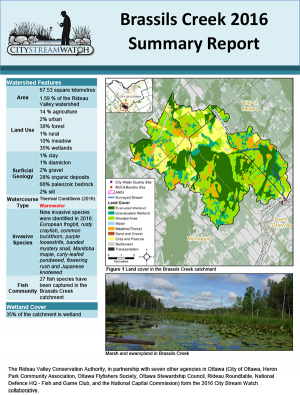
- 10 flood warnings and 13 drought messages issued release of the Middle Rideau Subwatershed Report and 10 catchment reports
For your copy of the RVCA 2016 Annual Report, visit www.rvca.ca or call 613-692-3571 or 1-800-267-3504 for a hard copy. To see what’s in store for 2017 take a look at our 2017 Budget and Work Plan which is also available online at our website.
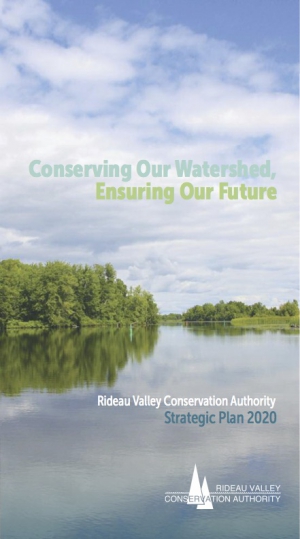
RVCA Launches Strategic Plan
A renewed vision for a thriving watershed will guide the Rideau Valley Conservation Authority (RVCA) during the coming years. The RVCA board of directors unveiled its new strategic plan at its board meeting held March 23. The plan builds upon the Conservation Authority’s past 50 years of success and will guide it towards a sustainable future.
RVCA Chair Lyle Pederson and General Manager Sommer Casgrain-Robertson are excited that the plan, entitled Conserving Our Watershed, Ensuring Our Future, charts a course to 2020. “We’ve worked hard to develop a set of strategies and plans that identify clear priorities for RVCA to undertake that are locally relevant,” said Chair Pederson. “These actions will bene t our local municipalities by protecting and restoring the value of our watershed.”
The RVCA’s renewed vision is for a thriving watershed with clean abundant water, natural shorelines, rich forests and wetlands, diverse habitat and sustainable land use that is valued and protected by all.
Four pillars guide program priorities to accomplish this vision:
- Develop and share watershed knowledge that advances decision making and leads to on-the-ground action
- Protect, restore and enhance watershed health and safeguard people and property from natural hazards
- Increase watershed awareness and appreciation and inspire action in others
- Operate a sustainable, well-managed, service-driven organization fueled by engaged employees
“All of our strategic priorities are also underpinned by ve core values,” added General Manager Sommer Casgrain-Robertson. “Collaboration, balance, knowledge, integrity and excellence shape all that we do and how we do it as we serve the Rideau watershed and the people who live in it”.
This strategic plan is just one of several products that guide the ongoing work and conservation e orts of the RVCA. The 2016 RVCA Annual Report, 2017 Budget and Work Plan along with information sheets for each of our member municipalities show the past, present and future of Conservation Authority e orts. To see the full strategic plan or any of these products, visit our website at www.rvca.ca (under “publications”) or call 1-800-267-3504 to have a copy mailed.
Conserving Our Watershed, Ensuring Our Future
Deep Freeze Slows Runoff
Cold temperatures have slowed runoff and will cause declining water levels in watershed lakes and streams through the weekend.
There is enough water moving through the system from the melt and rain that flows are still increasing in some tributaries. This will tail off today and levels can be expected to decline through the weekend. Weather forecasts indicate another warmup with some rain next week that could cause flows to increase again.
The warm temperatures and increased flows caused the ice on all waterbodies to become unstable. With refreezing occurring, new ice will be forming. However, it will take a few days for a consistent ice sheet to develop. All watershed residents, especially children, are advised to stay off of the ice on rivers and streams and avoid icy or wet streambanks where footing can be difficult.
Conservation Authority staff will continue to monitor conditions and issue further statements as conditions warrant.
RVCA Watershed Conditions Statements:
- Water Safety – High flows, unstable banks, melting ice or other factors that could be dangerous for recreational users such as anglers, canoeists, hikers, children, pets, etc. Flooding is not expected.
- Flood Outlook – Early notice of the potential for flooding based on weather forecasts, calling for heavy rain, snow melt, high winds or other conditions that could lead to high runoff, cause ice jams and/or lakeshore flooding or erosion.
- Flood Watch – Flooding is possible in specific watercourses or municipalities. Municipalities, emergency services and individuals in flood prone areas should prepare.
- Flood Warning – Flooding is imminent or already occurring in area watercourses.