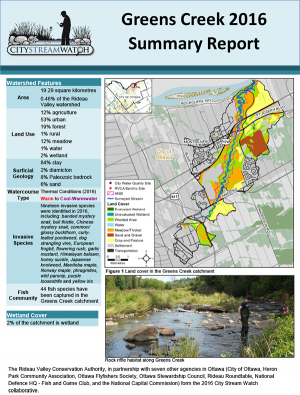
OOPS!
Sorry the page you are looking for does not exist.
YOU CAN EXPLORE OUR SITE USING THE NAVIGATION BELOW

Your Kindergarten class will be led through a series of age-appropriate, interactive activities suited to the season. Investigate what animals need to survive in different habitats through an outdoor scavenger hunt, get hands-on with animal pelts and skulls, and explore nature through fun play-based activities. Can be offered as a half-day or full-day program.
Above normal rain has received plenty of attention over recent weeks with close to a normal month worth of rain having fallen at several monitoring locations in the Rideau watershed in half the month of July. Most extreme is at the Ottawa Airport where 109 millimetres (mm) has fallen to date where 92 mm is the 30 year historical average. Normal precipitation on the watershed to mid-July is about 504 mm. This year, an average of 729 mm has been recorded.
After relatively high spring levels in April on Rideau watershed streams and lakes, rainfall has continued to keep levels above normal. The flow at the Rideau at Ottawa monitoring station reached about 160 cubic metres per second (cms) flow on July 3. The previous July highest recorded flow was 98 cms in 2008.
The Jock River has been unusually high compared to normal throughout the spring and early summer. The third peak of the year was also the highest on record for July, reaching 64 cms on July 3 as compared to 23 cms in July of 2009.
The snowmelt peak on Kemptville Creek of 56 cms on April 7 was below the highest recorded flow of 80 cms in 1972. The second peak on May 8, however, was about 45 cms, almost twice the previously recorded May high of 24 cms. Unlike what is ongoing on the Jock River, Kemptville Creek flows have not challenged previous records in July with relatively less rain falling in the headwater areas than in other locations in the watershed. Rainfall at the Brockville Airport climate station is at a surplus for the year to date of 52 mm with July rainfall
Similarly, recent July rains in the Tay River watershed have not been as heavy as in the Jock or Lower Rideau. The Rideau Canal reservoir lakes, Big Rideau, Upper Rideau, Wolfe and Bobs, are presently close to the respective targets. The outflow from Bobs Lake is still slightly above normal for the time of year. Fortunately, levels on Christie Lake are not being adversely affected unlike when close to 170 mm of rain was recorded at the monitoring station at Bobs Lake over the first week of May that did cause flooding issues on Christie Lake.
The impact of all the rain is obvious throughout the watershed with ponded water on many farm fields. Some golf courses and playing fields are unplayable. Residences and other buildings, some not close to a stream, are contending with saturated soils that are causing seepage through basement walls and floors.
Flows continue to be above normal throughout the watershed. July is typically a dry month, normal flow on the Jock River is about 1.7 cms but is well above that today at 30 cms. Rideau at Ottawa is about ten times normal for this date. Kemptville Creek is nine times normal. The Tay River flow in Perth is somewhat less at only twice normal. All flows will remain relatively high as long as the rain persists which is for the foreseeable future.
With the high flows in ditches and streams come slippery streambanks. Caution is needed and parents should advise their children of the danger.For water level and flow information in the Rideau system as well as the Ottawa River, visit the RVCA Streamflows and Water Levels webpage at http://his.rvca.ca/rvcafwl/ .
For more information about conditions on the Ottawa River, check the webpage of the Ottawa River Regulation Planning Board at http://ottawariver.ca/river-levels-flows.php#river-levels-flows-7-days .
RVCA Watershed Conditions Statements:
Unfortunately, due to COVID-19, we will not be offering any family programs at Baxter in the summer of 2020. Please check back in the spring of 2021 for more information.
Heavy rain that has fallen on the Rideau River watershed over the last week has caused some smaller streams to overtop their banks.
Rainfall on July 1 was varied over the watershed with 42 millimetres measured at the Ottawa Airport, 31 mm at Franktown in the upper Jock River watershed but less than 10 mm in Kemptville and Westport.
Flooding is not expected on the Rideau or the major tributaries, Tay and Jock Rivers and Kemptville Creek. However, safety is an issue around smaller streams that have fast flows with wet and muddy banks, for example, Stevens and Sawmill Creek. Parents need to inform their children of the dangers.
For water level and flow information in the Rideau system as well as the Ottawa River, visit the RVCA Streamflows and Water Levels webpage at http://his.rvca.ca/rvcafwl/ .
For more information about conditions on the Ottawa River, check the webpage of the Ottawa River Regulation Planning Board at http://ottawariver.ca/river-levels-flows.php#river-levels-flows-7-days.
RVCA Watershed Conditions Statements: