
Super User
Kemptville Creek Flood Risk Mapping - Floodplain Delineation Revision 3 (June 3, 2011)
Kemptville Creek Flood Risk Mapping - Floodplain Delineation Revision 2 (June 3, 2011)
Kemptville Creek Flood Risk Mapping - Floodplain Delineation Revision 1 (June 3, 2011)
With relatively minor rain forecast for the coming week and the flood waters in decline, the RVCA is withdrawing the Flood Watch that has been in effect for the last week.
Water levels are still above normal but continuing to decline. The 3-day rainfall of 35 millimetres presently forecast for Wednesday through Friday in eastern Ontario is expected to cause a pause in the decline. Periods of heavier, localized rain may fall in thunderstorms but no significant impact is expected at this time.
Waters have receded from the North Gower area where serious flooding along Stevens Creek occurred last week. Residents continue to be faced with the cleanup.
It will continue to be risky to be around dams in the Rideau system due to the higher than normal water. Boat wakes need to be controlled with slower speeds. Caution around the water for everyone is advised.
For water level and flow information in the Rideau system as well as the Ottawa River, visit the RVCA Streamflows and Water Levels webpage at: https://www.rvca.ca/watershed-programs/reporting/streamflow-water-levels.
For more information about conditions on the Ottawa River, check the webpage of the Ottawa River Regulation Planning Board at http://ottawariver.ca/river-levels-flows.php#river-levels-flows-7-days.
(WCS - 38/2017)
Floodwaters Receding Slowly
As Stevens Creek levels slowly decline, residents of North Gower continue to deal with water in basements and on streets as a result of record setting rainfall.
On the Rideau, minor flooding of low-lying areas on the Long Reach have access issues similar to what often occurs in the spring. Parks Canada staff are doing strategic dam operations to get water levels down throughout the Canal system with as little impact as possible.
With high flows passing through the dams, boaters are advised to stay well away. Also with high waters, boat wake becomes a problem causing damage to shorelines. The best choice is to leave the boat tied up or out of the water until normal navigation levels are reached. Also, boats and docks need to be well secured to avoid floating away.
No significant rain is presently in the forecast and, therefore, the decline in levels can be expected to continue over the next week. However, with the ground saturated and little capacity for infiltration, residents need to be aware that another bout of rain could cause runoff to go directly to the streams and flows to rapidly rise again.
All residents need to be aware of the dangers around all waterbodies especially close to the dams and locks in the Canal system.
For water level and flow information in the Rideau system as well as the Ottawa River, visit the RVCA Streamflows and Water Levels webpage at:
https://www.rvca.ca/watershed-programs/reporting/streamflow-water-levels
For more information about conditions on the Ottawa River, check the webpage of the Ottawa River Regulation Planning Board at http://ottawariver.ca/river-levels-flows.php#river-levels-flows-7-days .
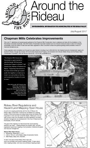
City of Ottawa Hazard Mapping Project
The Rideau Valley Conservation Authority (RVCA) is conducting several hazard mapping studies on watercourses within the City of Ottawa and the RVCA area of jurisdiction. For some watercourses, old mapping will be updated; and for others, hazards maps will be created for the first time.
Rideau River Hazard Mapping Studies
Project Status: Complete
Hogs Back to Kars & Kars to Burritts Rapids
The Rideau Valley Conservation Authority (RVCA) has completed two hazard mapping studies for the Rideau River: Hogs Back to Kars and Kars to Burritts Rapids. These studies update existing mapping in some areas and new mapping in others.
These maps are typically known as “floodplain mapping” and they show areas that are prone to natural hazards such as flooding, erosion and natural environment features such as wetlands. Both Rideau River studies look at identifying two main types of hazards along these stretches of the watercourse: flooding and slope stability.
When completed, the mapping will be used by the City of Ottawa and the Municipality of North Grenville when updating their Official Plan and Zoning Schedules and in the review of development applications under the Planning Act. RVCA will also use the mapping to guide the review of development applications submitted under the Province’s Development, Interference with Wetlands and Alterations to Shorelines and Watercourses Regulation.
Members of the public are encouraged to attend our open house and/or provide comments on the mapping below. Conservation Authority staff welcome historical records of past flood events, news clippings, photographs and even anecdotal stories to help confirm the reasonableness of calculations and resulting hazard mapping. For those unable to attend the open house, comments can be sent to Ferdous Ahmed, RVCA Senior Water Resources Engineer at .
These mapping studies are being completed as part of the City of Ottawa Hazard Mapping Project.
These studies are being done through a collaboration — known as the City of Ottawa Hazard Mapping Project — involving the City of Ottawa and the Mississippi Valley, Rideau Valley and South Nation Conservation Authorities. The City recognized a need to update its zoning schedules based on up-to-date flood risk mapping and has provided contributions enabling the Conservation Authorities to move ahead with these studies sooner than would otherwise be possible. The RVCA is currently working on several studies in the Ottawa area.
Flooding has occurred in areas of the Rideau Watershed as a result of rains that were closer to monthly totals than daily amounts.
The community of North Gower has had floodwaters in some homes and in the streets near Stevens Creek. Low-lying areas along the Rideau and its tributaries have also been flooded but no residential flooding has been reported or is expected in those areas at this time.
A weather system moving into eastern Ontario Wednesday night may bring more rain in thunder storms. What impact these storms will have will depend on timing, intensity and size. The decline of today’s high waters can be expected to be slowed if not reversed. Forecasts do not yet indicate how much rain can be expected.
As has been the case each month since February, precipitation amounts for July have been well above normals throughout the region. On several occasions this year, daily rains have set new records including yesterday when all Meteorological Service of Canada climate stations had rainfall well above previous record totals for the day. The Ottawa Airport received 79 millimetres (mm) yesterday compared to the previous 30 year record of 59 mm in 1987. The Brockville Climate Station at the Brockville Airport had 102 mm compared to 77.4 in 2005. Normal for July at the Brockville area station is 88.1 mm. At the RVCA precipitation monitoring station at Portland on Big Rideau Lake 117 mm was recorded.
The impacts of the unusual amounts of rain are obvious in the region. Crops in farm fields are being damaged by standing water. Golf courses and playing fields have had to be closed. With high flows and levels on area streams and lakes, boaters need to be aware of submerged obstacles and careful when approaching partially submerged docks. Mooring boats and securing docks has become a problem with the higher waters.
All residents need to be aware of the dangers around all waterbodies particularly children.
For water level and flow information in the Rideau system as well as the Ottawa River, visit the RVCA Streamflows and Water Levels webpage at http://his.rvca.ca/rvcafwl/ .
For more information about conditions on the Ottawa River, check the webpage of the Ottawa River Regulation Planning Board at http://ottawariver.ca/river-levels-flows.php#river-levels-flows-7-days .
Heavy Rains Forecast in Rideau River Watershed
Heavy rains forecast for Monday into Tuesday could cause rapid increases in water levels in small streams and raise rivers and lakes to above normal levels.
The Meteorological Service of Canada (MSC) has issued a Rainfall Warning that says “A slow moving upper disturbance over Lake Huron is expected to generate significant rainfall amounts over much of Eastern Ontario”. As much as 100 millimetres (mm) of rain is possible over a wide area.
A few days without rain provided some capacity for infiltration of the rain into the soil but that storage has been filled with water levels already on the rise from rainfall this morning. Levels will continue to increase throughout the day.
Flows in smaller streams could go over their banks with heavy localized rain in thunder storms. The rivers in the watershed are not expected to go to the onset of flooding but higher waters may affect navigation on lakes and rivers if normally visible hazards are submerged. Anyone boating on area lakes and rivers needs to be cautious and parents need to remind children of the risks of high levels in all waterbodies.
For water level and flow information in the Rideau system as well as the Ottawa River, visit the RVCA Streamflows and Water Levels webpage at http://his.rvca.ca/rvcafwl/ .
For more information about conditions on the Ottawa River, check the webpage of the Ottawa River Regulation Planning Board at http://ottawariver.ca/river-levels-flows.php#river-levels-flows-7-days.