
Super User
RIDEAU VALLEY, July 18, 2023 – In the war on invasive species, knowledge is the most potent weapon – and a free community workshop aims to arm the public with as much invasive species information as possible.
Focusing on identification and how to reduce their spread, the workshop on Saturday, July 29 will feature staff presentations as well as hands-on displays of invasive plants and animals.
“We’re hoping more members of the public will become familiar with these species and their impacts,” said Amanda Lange, RVCA’s Aquatic Habitat Monitoring Co-ordinator. “The more people know about invasive species, the more we can collectively work to curb their spread. And by reducing the spread, we can give our native species a fighting chance and promote a more balanced and diverse local ecosystem.”
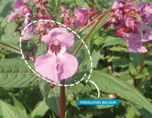
Invasive plants like Himalayan Balsam, garlic mustard, Japanese knotweed and dog-strangling vine can spread rapidly, pushing out native species and leaving gaps in the area’s biodiversity. This can reduce food supplies and resources for other species who rely on the missing native plants. Invasive plants are also often poor substitutes when it comes to erosion and flood mitigation, as their roots generally aren’t as deep or strong.
In the water, invasive aquatic species can have dramatic ecosystem impacts while also measurably changing water quality and characteristics. For example, invasive zebra mussels filter suspended particulates so effectively they can cause distinctly weedier lakes, since sunlight can reach further into the water column.
“We’re excited to welcome the public to learn what they can do in their own backyards to make a difference,” Lange said. “It’s a group effort to keep our local environment as natural and functional as possible for everyone’s benefit.”
The workshop will be held at the RVCA’s headquarters in Manotick from 9 a.m. to 12 p.m. on Saturday, July 29. All are welcome, including community associations, environmental groups, property owners, students, gardeners and anyone with an interest in learning about invasive species.
Light refreshments will be served. Advance registration is required.
-30-
WESTPORT, July 14, 2023 – A new weekly Forest School program will cater to kids ages 2 to 5 and their caregivers this September.
The parent-assisted program will run every Tuesday from 9:30 to 11:30 for 12 weeks, beginning Sept. 12.
“It’s so important to let young kids engage in risky play, explore a diverse landscape, develop their motor skills and of course receive all the wonderful benefits from being outside,” said Foley Mountain site supervisor Rebecca Whitman. “The sooner we can help children build connections to the land and nature, the better off we’ll all be.”
The Forest School model allows students to spend most of their time outside, playing and learning through experiential, hands-on activities that promote curiosity in an active and authentic learning environment. Foley Mountain has offered Forest School programs since 2018.
“We wanted to serve younger children, so we went with this parent-assisted model that serves a wider range of families,” Whitman said. Caregivers can help younger kids in the bathroom and help monitor risky play. It’s a great way to introduce younger kids to the Forest School environment – and the caregivers appreciate it, too.
“Especially when they’re little, they want to share this experience with their kids,” Whitman said.
Each week, the two-hour program will begin with free play prompts like mud kitchens, planks and boards, creature exploration, nature-based art, shelter building and seasonal activities. Then the group will gather for a snack and story – usually around the campfire – and decide on the day’s big adventure in the forest.
Whitman said this weekly program will differ from Foley’s popular monthly drop-ins, since the same group will come together each week throughout the season, fostering a sense of community and encouraging independence and social learning.
“It’s so rich for all those developmental opportunities,” Whitman said.
Registration is now open for the fall session at a cost of $216 plus HST. Families with slightly older or younger siblings are welcome to have them tag along.
Fall school-age and kinder Forest School programs are also open for registration. The half-day kinder program will run on Wednesdays starting Sept. 13 and the full and half-day programs for kids ages 6 to 12 will run on Thursdays beginning Sept. 14.
Visit https://www.rvca.ca/outdoor-education/foley-mountain-ca/foley-mountain-forest-scool to learn more and register.
-30-
(WCS-LW - 1/2023)
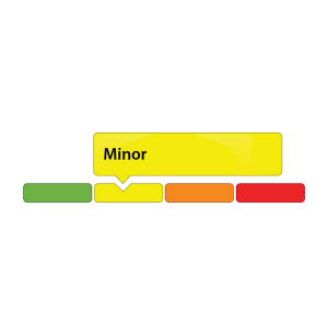
July 11, 2023 – Following a period of dry and hot weather, the Rideau Valley Low Water Response Team is declaring a MINOR low water status for the Tay River and Rideau Lakes watersheds (referred to as Upper Rideau Valley watershed), after officials met to discuss current watershed conditions on Monday, July 10, 2023.
Upper Rideau Valley watershed residents and businesses are encouraged to voluntarily reduce their water usage by 10 percent. This is especially important for those who have permits for taking water from surface or groundwater sources and all residents on private, communal or municipal wells. The requested voluntary water use reduction does not apply to residents of urban Ottawa because the City of Ottawa central drinking water system draws from the Ottawa River. All residents throughout the Rideau Valley watershed should be aware of any bans or bylaws that may be in place in their municipalities regarding watering or fire bans.
Over the last couple of months, rainfall amounts have been quite variable across the Rideau Valley watershed with some areas receiving above normal precipitation (urban Ottawa) but many other areas receiving limited rainfall. In general, the average 90-day rainfall measured at climate stations in the upper Rideau Valley watershed has been below 80 per cent of normal for this time of year which represents “minor” low water severity. Stream flow values for all regulated waterways (augmented from the reservoir lakes in the Tay River watershed) range from 60 to 70 per cent of normal for this time of year. Natural system stream flow values range from 30 to 50 per cent of normal for this time of year.
Parks Canada staff are closely monitoring the water levels throughout the Rideau Canal system inside the Rideau Valley watershed. The water levels in the reservoir lakes (Bob’s Lake and Wolfe Lake) are currently well below normal and are expected to decline further unless significant precipitation is received soon. Rideau River flows downstream of Big Rideau Lake have been reduced to minimum when possible. Water levels in the Rideau River below Smiths Falls are within navigable ranges.
Looking ahead, the seven-day weather forecast suggests we may receive up to 25 mm of rain across the watershed. If received, these rainfall amounts would slightly improve the 90-day rainfall deficit and the low stream flow values discussed above if the rainfall is distributed across all areas of the watershed.
To better understand local conditions, landowners, businesses, and industries are encouraged to contact Brian Stratton by email () if they are experiencing any unusual water-related problems.
Conservation Authority staff continue to monitor conditions and communicate with water managers throughout the watershed. Updates to this message will be issued as conditions warrant.
More resources:
Ministry of Environment, Conservation and Parks: https://www.ontario.ca/page/ministry-environment-conservation-parks
Ontario’s Low Water Response program: https://www.ontario.ca/page/low-water-response-program
RVCA website: www.rvca.ca
Hourly and daily streamflows and water levels: https://www.rvca.ca/watershed-monitoring-reporting/reporting/streamflow-water-levels
- end -
More Information:
Contact: Brian Stratton, RVCA Manager Engineering Services
Rideau Valley Conservation Authority
613-692-6804, 1-800-267-3504 ext. 1141
Rideau Valley Conservation Authority is a partnership of municipalities within the Rideau Valley watershed
created under the Conservation Authorities Act to deliver a range of programs in watershed management and
natural resource conservation.
Foley Mountain Forest School (Westport, ON) draft)
Foley Mountain Forest School offers an alternative education in which children spend most of their time outside, playing and learning through experiential, hands-on activities that promote curiosity in an active and authentic learning environment. Students will receive the benefits of repeated and regular visits to a natural area, in a play and inquiry-based education setting.
Tuition subsidies for the forest school program may be available for those who qualify. Please contact for more details.
Location: Foley Mountain Lane, Westport, ON — Google map
Programs that we offer:
- Family Forest School
- Kindergarten for children aged 4-5
- School age for children aged 6-12
- Family drop-in programs for all ages
PLEASE NOTE — We will consider offering additional program days if there is demand!
PLEASE READ our Forest School Frequently Asked Questions for more information.
NEW PROGRAM – Family Forest School
Is your child a bit too young to join in our independent programs or are you just looking to be a part of their forest school experience? Well, this new program may be the perfect fit for you!
- The same play based, child centred learning environment as our other forest school programs. Enjoy play, stories, snack time, forest adventures, and more!
- A new forest school program for children aged 2-5 (younger or slightly older siblings are welcome to tag along) where a parent or guardian stays with the child during the program.
- Tuesdays from 9:30am – 11:30am offered in the same fall, winter, and spring sessions as our other programs. Registration is for the whole session.
- Supported by one of our skilled and experienced forest school educators.
- Cost per child is $18/morning plus HST.
| Program | Date/Time | Cost |
| Fall 2024 – Tuesdays Registration open now |
Sept 10 – Nov 26, 2024/9:30am – 11:30am | $244.08 |
| Winter 2025 – Tuesdays | Jan 14 – March, 4/9:30am – 11:30am | $162.72 |
| Spring 2025 – Tuesdays | March 25-June 10, 4/9:30am – 11:30am | $244.08 |
To Register
Please complete the registration request form to be added to our registration list. Upon completion of the form, we will send you a registration package, including the program handbook and other necessary documents. PLEASE NOTE that filling out this form does not necessarily guarantee a space in the program but begins the registration process.
Kindergarten Program
- Children ages 4-5 years
- Program runs from 9am – 12pm
- Cost per child is $30/morning plus HST. All prices below include HST.
- Participants must be able to use the toilet independently
- Please check out our Frequently Asked Questions for more information.
| Program | Date/Time | Cost |
| Fall 2024 – Wednesdays REGISTRATION NOW OPEN! |
Sept 11 – Nov 27, 2024/9am – 12pm | $406.80 |
| Winter 2025 - Wednesdays | Jan 15 – March 5/9am – 12pm | $271.20 |
| Spring 2025 - Wednesdays | March 26 – June 11/9am-12pm | $406.80 |
To Register
Please complete the registration request form to be added to our registration list. Upon completion of the form, we will send you a registration package, including the program handbook and other necessary documents. PLEASE NOTE that filling out this form does not necessarily guarantee a space in the program but begins the registration process.
School Age Program
- For children aged 6–12
- Cost per child is $55/full day or $30/half day plus HST. All prices below include HST.
|
Program Session |
Date/Time |
Cost |
| Fall 2024 - Thursdays, Full Day REGISTRATION NOW OPEN! |
Sept 12 - Nov 28, 2023/9am - 3pm | $745.80 |
| Fall 2024 - Thursdays, Half Day REGISTRATION NOW OPEN! |
Sept 12 - Nov 28, 2023/9am - 12pm | $406.80 |
| Winter 2025 – Thursdays, Full Day | Jan 16 – Mar 6, 2025/9am - 3pm | $497.20 |
| Winter 2025 – Thursdays, Half Day | Jan 16 – Mar 6, 2025/9am - 12pm | $271.20 |
| Spring 2025 – Thursdays, Full Day | March 27 – June 12, 2025/9am - 3pm | $745.80 |
| Spring 2025 – Thursdays, Half Day | March 27 – June 12, 2025/9am - 12pm | $406.80 |
To Register
Please complete the registration request form to be added to our registration list. Upon completion of the form, we will send you a registration package, including the program handbook and other necessary documents. PLEASE NOTE that filling out this form does not necessarily guarantee a space in the program but begins the registration process.
Forest School FREE Family Drop In Programs
Pack up the family and head down to Foley Mountain Conservation Area to explore, adventure, play, and learn in the forest! Thanks to the Township of Rideau Lakes, we are offering FREE family drop-in program.
2024 Drop In Programs
- April 20, from 10-11:30 am Waitlist Only
- May 18, from 10-11:30 am Waitlist Only
- June 15, from 10-11:30 am Waitlist Only
- July 20, from 10-11:30 am
- August 17, from 10-11:30 am
- September 21, from 10-11:30 am
- October 19, from 10-11:30 am
- November 16, from 10-11:30 am
- December 21, from 10-11:30 am
General Information:
- All ages of children welcome, children must be accompanied by an adult
- PRE-REGISTRATION IS REQUIRED and group size will be limited - please complete the registration request form to pre-register or be added to the waitlist.
- FREE of cost
| Our Community Partners | ||||||
| |
|
 |
 |
|||
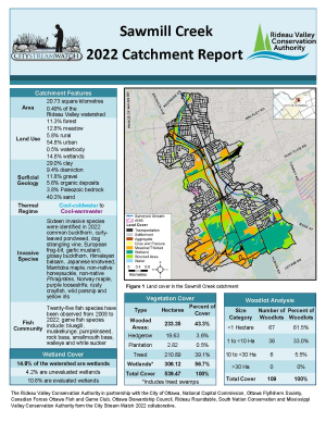
RIDEAU VALLEY, June 6, 2023 — New accessible infrastructure, expanded septic services, a new clean water program and the planting of our 7 millionth tree: the Rideau Valley Conservation Authority (RVCA) accomplished all this and more in 2022.
The RVCA provides conservation-led programs and services based on a watershed-wide model serving 18 member municipalities along the Rideau River and its tributaries. Our wide-ranging programs cover a huge geographic area of more than 4,000 km2, from Central Frontenac to Merrickville-Wolford and downriver to the City of Ottawa. Through science, stewardship and education, the RVCA strives to manage local natural resources sustainably to ensure a healthy watershed for the future.
A newly-released 2022 annual report highlights RVCA’s many accomplishments over the year, including:
- 317,000 people visited RVCA conservation areas in 2022 (up from 200,000 annually pre-pandemic)
- 6,783 students participated in outdoor education programs at Baxter and Foley Mountain Conservation Areas
- 2 accessible bridge projects begun at our most popular conservation areas (1 each at Baxter and Chapman Mills conservation areas)
- 239,595 trees planted (7 million planted since 1984)
- 10,127 trees and shrubs planted on 69 waterfront properties
- 3,687m2 of invasive species removed during 12 volunteer removal events
- 1,392 Planning Act applications reviewed
- 353 Section 28 applications processed under the Conservation Authorities Act
- 734 septic system applications processed for new or replacement septic systems across nine municipalities
- 117 sites sampled for water quality on lakes, rivers and major tributaries
- 196 Clean Water Projects completed in partnership with landowners
- 2,050 healthy butternut seedlings distributed to help replace dead and dying butternut trees in Eastern Ontario
- Restoration continued at the Stillwater Wetland Complex (Nepean) and the Hutton Creek Marsh Wetland (Lombardy)
Staff also met strict approval and customer service goals, issuing 99% of Section 28 permits within provincial timelines and issuing most septic permits within half the provincial timelines.
“Staff work tirelessly to ensure the watershed is healthy and thriving for all who call it home,” said Sommer Casgrain-Robertson, RVCA General Manager. “We are extremely proud of our municipally-supported programs that look to build resilient communities in the face of climate change and population growth.”
We extend our thanks to our member municipalities, partners and volunteers who made 2022 such a success and we look forward to a productive 2023.
Download the RVCA’s 2022 Annual Report at www.rvca.ca or call 613-692-3571 or 1-800-267-3504 to request a hard copy.
-30-