
Conservation Areas (77)
Snowshoeing
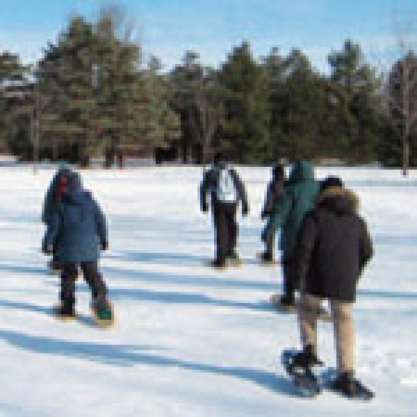
Come and experience one of the oldest forms of transportation in Canada! Students will learn how to safely travel with snowshoes and, once comfortable, follow the snowshoe trail through the forest and maybe even try snowshoe games.
Additional Info
- Grade 1, 2, 3, 4, 5, 6, 7, 8, 9, 10, 11, 12
- Season Winter
The Rideau Valley Conservation Authority offers outdoor education programming year round for nursery schools, day cares, home schooling groups, public and private schools, and community groups at Baxter Conservation Area and Foley Mountain Conservation Area.
Programs can be a half day or a full day and can take place weekdays or weekends all year long. Outdoor education programs at Baxter Conservation Area and Foley Mountain Conservation Area provide students with a strong understanding of our natural world, how it functions and how we, as humans, fit into it. All our programs are interactive and experiential to provide students with a “hands-on” approach to learning about natural science in our “Ecology Lab.”
If you don’t see a program that meets your group’s objectives, please give us a call — and our Interpreters will create one for you!
Baxter Conservation Area
Baxter Conservation Area is located on the shores of the Rideau River, five minutes south of Kars and North Gower. It is owned and operated by the Rideau Valley Conservation Authority.
Baxter is 180 acres of mixed forest, open meadow, wetlands, beach, group camping areas and nut tree plantation. There are five kilometers of trails and boardwalks that provide wonderful, safe access for forest, meadow and wetland exploration.
The Patrick McManus Interpretive Centre is Baxter’s program headquarters which can accommodate two to three classes as a starting point for an exciting day of outdoor learning.
Foley Mountain Conservation Area
Foley Mountain Conservation Area is located high atop a granite ridge overlooking the Upper Rideau lake and picturesque village of Westport, 50 km south of Perth. It is owned and operated by the Rideau Valley Conservation Authority.
The Conservation Area consists of 800 acres of mixed forests, ponds, and fields. The eight hiking trails, group camp area, scenic Spy Rock lookout, and picnic areas set the stage for a quality outdoor education experience.
The outdoor environmental education program at Foley Mountain provides students with interactive, experiential, curriculum-based experiences that will help them to understand our natural world and their relationship with it. The Program can accommodate up to 60 students per day and all equipment is provided. All programs are approximately 1.5 hours in duration.
The RVCA is pleased to offer resources to teachers interested in promoting spring water awareness.
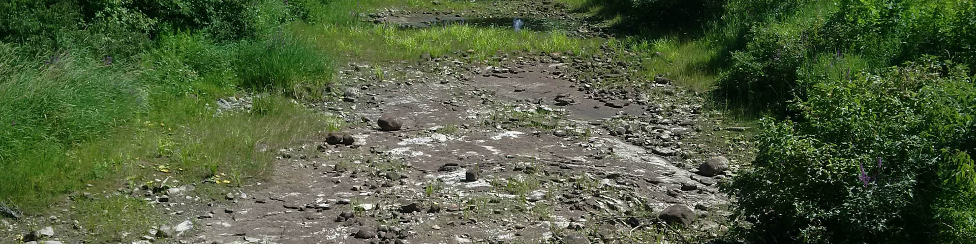
As the warmer spring weather approaches, snow and ice begin to melt and waterways begin to fill up with cold, fast moving water. Children are often interested in exploring rushing streams and thawing ponds during the warm days of spring. However, these areas can be unsafe and it is important to teach students the dangers of these areas.
Resources include:
- Background information about spring flooding
- “Safety Says” video with teacher notes
- Activity ideas, resources, and sheets for use by classroom teachers
- General curriculum information
- Announcement information for use during the spring season
- Information for students to take home during flood season
- Posters
- Dam safety resource materials from Ontario Power Generation
Please feel free to copy and distribute any of the information in this package. To order a print version of this package or if you have any questions about the information, please contact Rebecca Whitman, at 613-273-3255 or Andrea Wood at 613-489-3592.
SWAP Resources for Teachers
- SWAP Background Information
- SWAP 8.5 x 11-inch colour poster
- SWAP 8.5 x 5.5-inch colour flyer (two per page)
- SWAP 8.5 x 5.5-inch black and white flyer (two per page)
- SWAP PowerPoint Presentation
- SWAP Safety Announcements
- SWAP Safety Extension Activities
- SWAP Curriculum Connections
Experiments
Games
- SWAP Word Search Game
- SWAP Word Search Answers
- SWAP Safe or Not Safe (colouring page)
- SWAP Home Safely Game
- SWAP Tic Tac Toe (PowerPoint)
Video
- Safety Says Video — Thanks to Quinte Conservation and Loyalist College for the use of their “Safety Says video
63 Royal York Street
Richmond, Ontario
Phone: 613-692-3571 ext. 1100
Open year round
Dawn to dusk
subject to winter conditions
Activities and Amenities
![]()
![]()
![]()
![]()
![]()
A wonderful waterfront picnic area with a dock to launch canoes and kayaks for a quiet trip on the Jock River.
Trails: 0.4km
Special Features
- Short nature trail
- Car top boat launch
Please use caution on the water! The Rideau River is part of a busy navigation channel. It is every boater's responsibility to know the hazards along their route and to ensure they have proper safety equipment on board. For a list of required equipment and complete rules and regulations, visit Transport Canada’s Office of Boating Safety and read the Safe Boating Guide.
500 County Rd 1
Lombardy, Ontario K7A 4S4
Phone: 613-692-3571 ext. 1100
Open year round
Dawn to dusk
subject to winter conditions
Activities and Amenities
![]()
![]()
![]()
![]()
A simple, quiet spot to reconnect with nature. Enjoy a scenic view of the impressive Hutton Creek Marsh. Take a short stroll to a bench along the babbling Hutton Creek.
Trails: 0.5 km
Special Features
- Scenic view of the Hutton Creek Marsh
- Retired, historic Motts Mills Dam
- Newly constructed Motts Mills Berm
- Short trail
4774 Briton-Houghton Bay Road
Rideau Lakes, Ontario
Phone: 613-692-3571 ext. 1100
Open year round
Dawn to dusk
subject to winter conditions
Activities and Amenities
![]()
![]()
![]()
![]()
![]()
![]()
![]()
Peaceful and serene, Mill Pond has six kilometres of wilderness trails. Take a hike through the park and stop for a quiet picnic in the sugar bush or at the covered picnic shelter. Mill Pond has a boat launch (car top only) for those who would like to enjoy a quiet canoe trip.
Trails: 6km
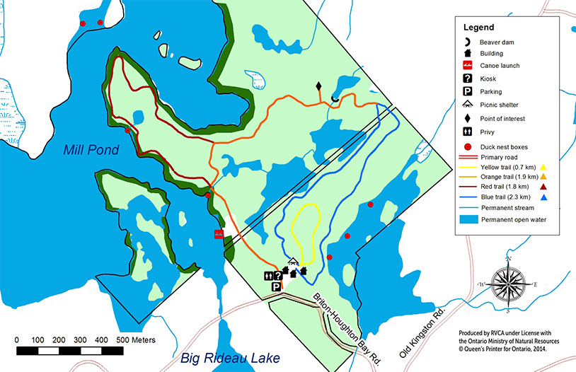 Download the PDF
 Open Avenza map
Please use caution on the water! The Rideau River is part of a busy navigation channel. It is every boater's responsibility to know the hazards along their route and to ensure they have proper safety equipment on board. For a list of required equipment and complete rules and regulations, visit Transport Canada’s Office of Boating Safety and read the Safe Boating Guide.
1392 N Anderson Rd
Phone: 613-692-3571 ext. 1100
Open year round
Dawn to dusk
subject to winter conditions
Activities and Amenities
![]()
![]()
The Meisel Woods Conservation Area is 130-acres of excellent Precambrian Shield land. It is a forested natural area with plants, animals and landscape typical of the headwaters of the Tay and Upper Rideau watershed. The property surrounds a 60-acre, headwaters lake known as Beaver or Bass Lake and includes additional waterfrontage on Crow Lake.
The property was generously donated to the Rideau Valley Conservation Foundation by John Meisel in 2000. Mr. Meisel’s interest is that the property remain undeveloped. That wish will be respected. The goal of the new Meisel Woods Conservation Area is environmental protection. The only improvements foreseen are along the trail, with the creation of a small parking lot and a sign.
Trails: 5km
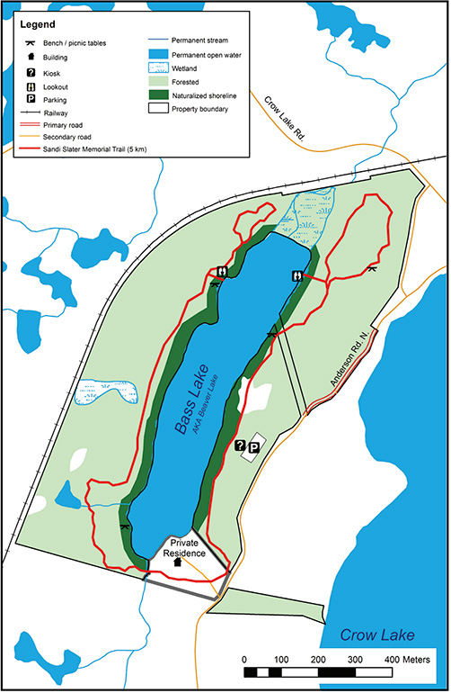 Download the PDF
 Open Avenza map
Special Feature - In Loving Memory — The Sandi Slater Memorial Walk
Joe and Sandi Slater, neighbours of Mr. Meisel, regularly walked through the woods and around the lake for recreation and tranquility. On the sudden passing of Mrs. Slater in the spring of 2003, and with the collaboration of Mr. Meisel, memorial gifts were directed towards the establishment of the Sandi Slater Memorial Walk. The Walk is now a central feature of the new Meisel Woods Conservation Area and more safety and access improvements are planned in the future. Phase one is complete, and with your generous donations, we can complete phase two of the trail that will lead around Bass Lake — that same trail of peace, quiet and reflection that the Slaters had enjoyed for many years.
With Thanks
The opening of this new public property in Central Frontenac is the result of a whole community of effort and all involved are to be heartily congratulated on their thoughtful and generous gesture. In particular, Mr. John Meisel, Professor Emeritus of Queens University, Mr Joe Slater, dedicated and hardworking community gentleman, and the many donors and volunteers to the cause deserve our heartfelt gratitude. The property is a major investment in the quality of life in Central Frontenac and the upper Rideau watershed.
253 Winding Way
Ottawa, Ontario
Phone: 613-692-3571 ext. 1100
Open year round
Dawn to dusk
subject to winter conditions
Activities and Amenities
![]()
![]()
![]()
![]()
![]()
![]()
![]()
This wonderful 23-acre parcel of conservation land is located on the west bank of the Rideau River on Prince of Wales Drive between Winding Way and Lodge Road. It consists mainly of natural river shoreline, wetlands and flood plain areas that are unique in the City of Ottawa. It forms a passive recreational area for the Chapman Mills community. Parking is located off Winding Way. Come enjoy the picnic shelter, scenic lookouts along the trail, walkways and boardwalks that lead pedestrians on a 1.5 km stroll through some sensitive and beautiful habitats, and read the interpretive signs telling the environmental story at points along the path.
The land for Chapman Mills Conservation Areas was a gift to the people of the Rideau Valley from the South Nepean Development Corporation, along with additional land ceded from Parks Canada. Minto Development Inc. provided the development funds necessary to carry out the improvements for public use of Chapman Mills Conservation Area.
Trails: 1.5km
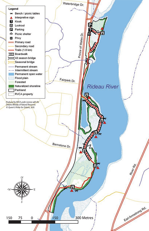 Download the PDF
 Open Avenza map
Please use caution on the water! The Rideau River is part of a busy navigation channel.It is every boater's responsibility to know the hazards along their route and to ensure they have proper safety equipment on board. For a list of required equipment and complete rules and regulations, visit Transport Canada’s Office of Boating Safety and read the Safe Boating Guide. Please note that swimming is prohibited at Chapman Mills Conservation Area.
Special Feature - Fish Habitat Creation Projects
Chapman Mills Conservation Area is the site of two “fish habitat compensation projects” to improve the quantity and quality of fish habitat along the Rideau River shoreline within the City of Ottawa.
Interpretive signs created for the projects
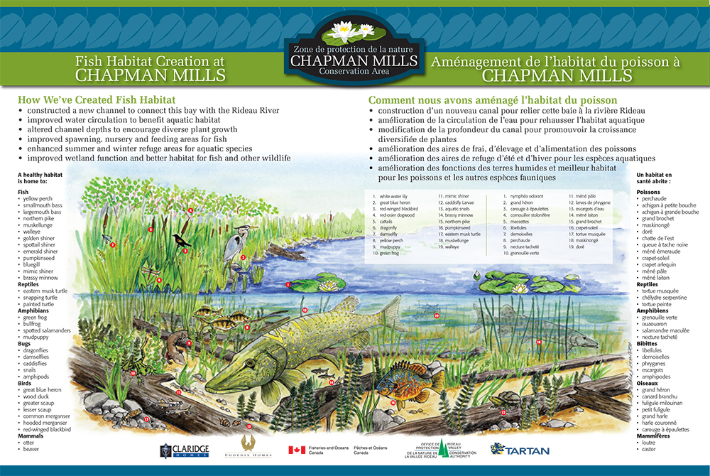 Fish Habitat Creation at Chapman Mills (click to enlarge)
 Habitat Enhancement at Chapman Mills - click to enlarge

With support through the Canada 150 Community Infrastructure Program/Avec l’appui du Programme d’infrastructure communautaire de Canada 150.
3240 River Road
Ottawa,Ontario
Phone: 613-692-3571 ext. 1100
Dawn to dusk
Activities and Amenities
![]()
![]()
![]()
![]()
![]()
![]()
W. A. Taylor is set along the beautiful Rideau River and is one of the best spots to launch your boat or enjoy a quiet picnic with the family. Picnic tables and privies are on site.
Trails: 1.0km
![]() W. A. Taylor Conservation Area Trail Map
W. A. Taylor Conservation Area Trail Map
Special Features
- short nature trail
- boat launch
- picnic area
Please use caution on the water! The Rideau River is part of a busy navigation channel. It is every boater's responsibility to know the hazards along their route and to ensure they have proper safety equipment on board. For a list of required equipment and complete rules and regulations, visit Transport Canada’s Office of Boating Safety and read the Safe Boating Guide.
More...
133 Yacht Club Rd
Rideau Ferry, Ontario
Phone: 613-692-3571 ext. 1100
Dawn to dusk
Activities and Amenities
![]()
![]()
![]()
![]()
![]()
![]()
![]()
![]()
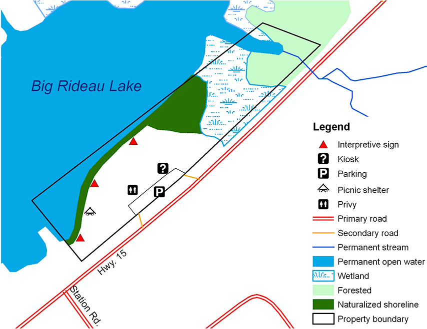
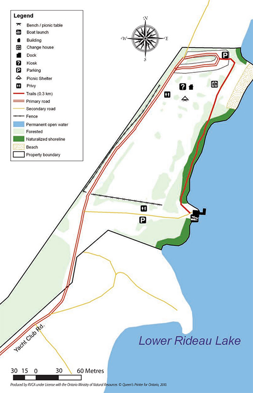
Bask on the beach and listen as the water laps onto the shore at the Rideau Ferry Yacht Club Conservation Area. The former Rideau Ferry Yacht Club donated this 10 acre shoreline property located at Rideau Ferry to RVCA in 1976 for the purpose of providing a public day use recreation area with access to Lower Rideau lake. Rideau Valley Conservation Authority maintains a public beach, boat launch, and picnic area at this popular summer park.
 Download the PDF
 Open Avenza map
Trails: 0.3km
![]() Rideau Ferry Yacht Club Trail Map
Rideau Ferry Yacht Club Trail Map
Special Features
- sandy beach
- boat launch
- picnic shelter, picnic tables and barbeques
Beach Advisories and Boat Safety
For listings of current advisories, please visit the Leeds, Grenville & Lanark District Health Unit.
Please use caution on the water! The Rideau River is part of a busy navigation channel. It is every boater's responsibility to know the hazards along their route and to ensure they have proper safety equipment on board. For a list of required equipment and complete rules and regulations, visit Transport Canada’s Office of Boating Safety and read the Safe Boating Guide.
100 Wild Life Rd,
Perth, ON
Phone: 613-692-3571 ext. 1100
Activities and Amenities
![]()
![]()
![]()
![]()
![]()
![]()
![]()
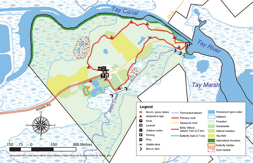
Located on the Tay Marsh, this watery environment nurtures a variety of diverse plant and wildlife species. Deer, ducks, Canada geese, rabbits, bluebirds and wild turkeys are some of the wildlife that is found in this 257-hectare reserve. This conservation area is specifically geared to wildlife management. This is an area for quiet observations. Take your time and keep your eyes open.
Trails: 3.5km
 Download the PDF
 Open Avenza map
Special Features
- Tay Marsh lookout
- Wildlife
- Self-guided trail brochure available
- Interpretive signs
Please use caution on the water! The Rideau River is part of a busy navigation channel. It is every boater's responsibility to know the hazards along their route and to ensure they have proper safety equipment on board. For a list of required equipment and complete rules and regulations, visit Transport Canada’s Office of Boating Safety and read the Safe Boating Guide.
Foley Mountain Lane
Westport, ON K0G 1X0
Phone: 613-273-3255

Open year round
8:30 a.m. to dusk
subject to winter conditions
Activities and Amenities
![]()
![]()
![]()
![]()
![]()
![]()
![]()
![]()
![]()
![]()
![]()
![]()
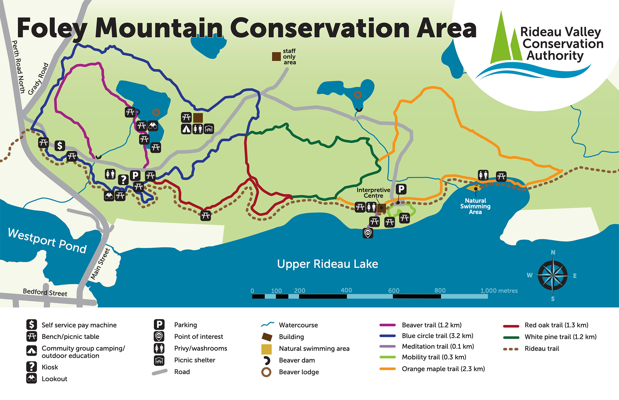
High atop a granite ridge overlooking the historic Upper Rideau waterway and Village of Westport is Foley Mountain. Foley is famous for its dynamic, hands-on, education programs for school children and youth groups. Enjoy the scenic lookout, hiking trails and picnic areas.
Purchasing a Pass
- $8 day pass / $55 annual pass
- Pay machine on site that accepts COIN and CREDIT CARD. Credit card purchases are processed via cell networks. Due to our remote location, connections are sometimes slow. Please be patient!
- Go high tech with PayByPhone and purchase your pass online, using the app, or over the phone.
Trails: 10km
 Download the PDF
 Open Avenza map
Special Features
- Spy Rock scenic lookout
- Interpretive centre
- Discovery Centre
- Education programs and day camps
- Natural swimming area
- Hiking and snowshoeing trails
- Facility rental
- Group camping for organized groups such as Guiding, Scouting, and community organizations
Beach Advisories
For listings of current advisories, please visit the Leeds, Grenville & Lanark District Health Unit.
Outdoor recreation in a natural setting has proven physical, mental and spiritual health benefits. It’s important to ensure these special areas are being properly to protect the significant species found in our Conservation Areas, while allowing everyone to enjoy and benefit from them.
Conservation Area Rules include:
- No dogs on beach or in the water
- All dogs must be on leash
- Please clean up after your pet
- Closed dusk to dawn
- All garbage in cans and recycle containers
- All visitors must pay fee before using site facilities
- All group activities are by permit only
- Camping by permit only
- No motorized vehicles allowed on trails
- Authorized use of trail only (hiking/walking)
- Do not damage property
- Do not remove or destroy the wildlife/vegetation
- No Hunting
- Access to water in designated areas only
- Fires allowed by permit only
- Open year round but subject to winter conditions
- No overnight parking
Explore with confidence using Avenza Maps
Visitors to RVCA’s conservation areas can now navigate even our most remote trails with confidence thanks to a new partnership with Avenza Maps. The Toronto-based mobile app offers GPS-enabled maps that can be used offline and without cell service to help you keep your bearings even in the deepest woods.
The app is supported by Android and iOS. Instructions on how to get started and use the mobile app can be found at https://www.avenzamaps.com/maps/how-it-works.html. QR codes for the RVCA’s Avenza maps can be found at the trailheads of eight conservation areas, and can also be found on their property-specific webpages. Scanning these QR codes will download RVCA’s maps to your phone to take out onto the trail. If you don't have Avenza Maps, you will be guided through the installation process. To avoid installation issues, the RVCA encourages visitors to download the free app before leaving home.
Traditional trailhead maps and printed brochures will continue to be available, as well as downloadable PDF maps.