
Super User
Septic Re-inspection Program
The Mississippi and Rideau Valley Conservation Authorities offer a re-inspection program to interested municipalities through the Mississippi Rideau Septic System Office.
Why Re-inspect Septic Systems?
Malfunctioning on-site sewage systems can have both human health and environmental impacts beyond the property on which it is located. Nutrient and bacteria-rich effluent can travel through soil and rock fractures to surface water bodies, and ground water sources. Contamination of surface water can cause excessive aquatic plant growth, depletion of oxygen in lakes, and impact the natural habitat for aquatic species. Ground water contamination can cause illness and even death. This makes it crucial that property owners be aware of the location and operation of their septic system. Under the Ontario Building Code it is the property owner’s responsibility to ensure that their sewage system is working properly, not only for their health, but also that of the surrounding community and environment. This re-inspection program gives property owners the confidence that their system is operating property — avoiding contamination of surface and groundwater.
History of the Program
Tay Valley Township has led the way locally for the sewage system re-inspection program as well as other initiatives that work towards protecting the quality of surface and ground water. Since the sewage system re-inspection pilot program in 2000, the Township has now inspected thousands of waterfront properties. The program combines the education of the homeowner regarding the maintenance of their sewage system with an inspection component. A follow-up component is also essential to ensure that the program effectively manages identified sewage system problems.
Voluntary Vs. Mandatory Inspections
Municipalities, under the Ontario Building Code, can run voluntary septic system re-inspection program or a discretionary program with mandatory inspections.
The steps taken for the septic re-inspection program are exactly the same for the voluntary and mandatory programs. The only difference is that property owners under the mandatory component are required to participate in the program when their property has been identified, whereas property owners under the voluntary component can choose whether or not to participate.
The Mandatory Re-inspection Program applies to all properties located in the following regions:
1. Within the Tay Valley Township on:
- Adam Lake
- Bennett Lake
- Bob’s Lake
- Farren Lake
- Little Silver Lake
- Long Lake
- Otty Lake
- Pike Lake
- Rainbow Lake
2. Township of Rideau Lakes
3. Central Frontenac
The Voluntary Re-inspection Program encompasses waterfront properties in the following townships:
1. The remainder of Tay Valley Township
2. North Frontenac
To book your inspection or learn more about the program, contact:
Eric Kohlsmith, Septic Inspector
Mississippi Rideau Septic System Office
10970 Highway 7, Carleton Place Ontario K7C 3P1
613-253-0006 ext. 256
Ottawa Hazard Mapping Public Open Houses
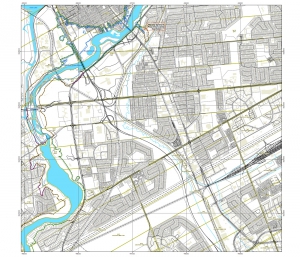
Members of the public are invited to an upcoming open house to review hazard maps. The RVCA has just completed a review and update of existing hazard maps (floodplain and steep slopes) along the Rideau River from Hogs Back to Rideau Falls.
These maps are typically known as “floodplain mapping,” but they also show areas that are prone to natural hazards such as flooding, erosion and unstable slopes and natural environment features such as wetlands. The mapping takes these features into consideration and will be used by the City of Ottawa and the Conservation Authority when updating Official Plans and Zoning Schedules and in the review of other related Planning Act applications. RVCA will also use this mapping to guide the review of for construction applications in environmentally sensitive areas such as wetlands, shorelines and waterways and along steep slopes.
The goal of this mapping is to help ensure that sound planning decisions are made — keeping people and property safe. Accurate engineered hazard mapping is the foundation of effective floodplain and resource management.
Members of the public are encouraged to the open houses and/or provide comments on the draft mapping.
Open House
November 8, 2016 from 4 to 8 p.m.
Brewer Park Pool
100 Brewer Way, Ottawa
Lounge Room
Conservation Authority staff welcome historical records of past flood events, news clippings, photographs and even anecdotal stories to help confirm the reasonableness of calculations and resulting hazard mapping. Local residents are encouraged to share their knowledge to help the Conservation Authority further refine these maps.
For those unable to attend an open house, mapping can also be seen online at www.rvca.ca and comments sent to . The Rideau Valley Conservation Authority (RVCA) is one of three Conservation Authorities working on updating and improving hazard maps on behalf of the City of Ottawa. Mississippi Valley Conservation Authority and South Nation Conservation are also working on similar projects in their watershed.
About Clean Water Grants
Rural Clean Water Grants help to improve water quality in our local rivers, streams and creeks by reducing pollution and volume of water running off the land. Teaming up with rural residents, financial support and technical assistance are available for on-the-ground projects that improve and protect water quality.
Rural Clean Water Grants are available through one of two programs based on location:
- Ottawa Rural Clean Water Program for properties in the City of Ottawa
- Rideau Valley Rural Clean Water Program for properties outside the City of Ottawa, but in the remainder of the Rideau Valley.