Super User
Ottawa Conservation Authorities to Work with Provincial and Municipal Partners on Flooding Strategy

March 12, 2020 — With the spring thaw top of mind for residents who were affected by significant flooding along the Ottawa River in 2019, the Mississippi Valley, Rideau Valley and South Nation Conservation Authorities welcome the coordinated approach that Ontario proposes to build between federal and provincial governments, local municipalities, Conservation Authorities and indigenous partners to protect people and property from the devastating and costly impacts of flooding.
On March 9, 2020, John Yakabuski, the Minister of Natural Resources and Forestry, released Ontario’s Flooding Strategy in response to the Flood Advisor’s 2019 Report, clearly indicating that Conservation Authorities will have a continued role to play in the shared responsibility on strengthening the approach to flooding.
According to Minister Yakabuski in a news release published by the Province on March 9: "We're listening to people from across the province who have been affected by flooding, and that is why we're taking a whole-of-government approach and calling on the federal government, our municipal partners, conservation authorities, industry and Indigenous communities to work with us to implement the actions contained in this strategy."
The Strategy focuses on five priority areas:
- Understanding Flood Riskthrough updated floodplain mapping and increasing access to flood-related information.
- Strengthening Governance through provincial policy to ensure local development is directed away from areas where flooding and erosion present unacceptable risks.
- Enhancing Flood Preparednessusingstate-of-the art science and technology.
- Enhancing Response and Recoveryby improving how we receive and respond to municipal requests for assistance.
- Investing in Flood Risk Reductionby working with the federal government to increase investment in critical areas like mapping and infrastructure.
Ontario’s Flooding Strategy also calls for the update of existing natural hazard technical guidelines used to support municipal and Conservation Authority implementation of flood programs and activities, which was a key request throughout consultations.
“We are pleased to be working with the Province and sharing our flood management expertise and watershed approach to deliver services and programs,” said Sally McIntyre, General Manager, Mississippi Valley Conservation Authority. “We look forward to learning how the Strategy will support sustainable funding for flood forecasting and operations, flood proofing of existing structures and stewardship of wetlands to mitigate flooding.”
“We look forward to enhancing our long-standing partnership with the province,” said Sommer Casgrain-Robertson, General Manager, Rideau Valley Conservation Authority. “Local Conservation Authorities are well-positioned to support the province’s strategy and we will look to better serve our watershed municipalities and residents through our unique watershed approach and our extensive expertise and experience in flood risk management, mitigation
and preparedness.”
“We thank the Provincial Government for highlighting the important role that Conservation Authorities play in understanding flood risk and mitigation within the Ontario Flooding Strategy,” said Angela Coleman, General Manager and Secretary Treasurer, South Nation Conservation. “We look forward to working with all levels of Government to better protect people and property from natural hazards, such as flooding.”
– end —
Winter Work on Hutton Creek Marsh Restoration Complete
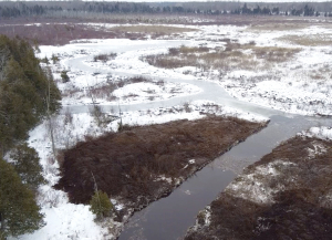
ELIZABETHTOWN-KITLEY, March 11, 2020 – Winter restoration work on the Hutton Creek Marsh is now complete to the delight of the many dedicated partners who made the project possible.
This work completes Phase 2 of a long-term project to bring the provincially significant wetland near Lombardy back to a more natural, productive state. Over the years, the provincially significant wetland located near Lombardy had become a monoculture: choked and overgrown with cattails. Only 10 per cent of the marsh was open water which had negative impacts on its biology, ecology and hydrology.
Hutton Creek Marsh is an amazing sample of Ontario’s provincially significant wetlands. This 300-hectare marsh found upstream of the Motts Mills Berm is part of the much larger Otter Lake - Hutton Creek Wetland Complex which covers 722 hectares. Five individual wetlands make up a palustrine wetland complex, meaning there is a permanent flow of surface water into the wetland from various creeks and out below the Motts Mills Berm into Hutton Creek and on downstream to the Rideau River.
In 2015, the nearby Motts Mills Dam was decommissioned and replaced with an earthen berm. In 2017, the Rideau Valley Conservation Authority (RVCA) lowered local water levels to help staff study the wetland and determine the best way to address the crowded cattails. In 2019, work began to increase the open water features of the marsh. Crews looked to build 1.5 acres of open water ponds and add 500 metres of channels to help return the wetland to a healthier hemi-marsh state (50 per cent vegetation and 50 per cent open water).
These improvements will support increased diversity for various plants, mammals, birds, reptiles, amphibians and turtles. This healthier water-to-vegetation ratio is also ideal for waterfowl. Creating more open water will also restore local access for paddling and hunting. It is hoped that the diversity and abundance of species will return to what was in the 1970s and 1980s.
Some final work will be done this in the coming months to add habitat structures, distribute vegetation seeds and plant water-loving shrubs at the construction site.
Special thanks to the dedicated group of local stakeholders and funders who made this project possible including Ducks Unlimited Canada, Leeds and Grenville Stewardship Council, Ontario Federation of Anglers and Hunters Zone F, the United Counties of Leeds and Grenville (UCLG), Wildlife Habitat Canada, Rideau Valley Conservation Authority and the Rideau Valley Conservation Foundation.
– end —
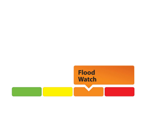
Flood Watch - Water Levels Rising on Stevens Creek and Taylor Drain in the Village North Gower
(WCS – NG01/2020)
March 10, 2020 – The mild weather yesterday and today has melted a significant amount of snow in the Rideau Valley Watershed. This snow melt together with some rainfall is causing the water levels to rise quickly in Stevens Creek and Taylor Drain. Based on new water level gauges installed in the spring of 2019, it appears that the water may breach the banks and cause localized flooding within the low-lying areas along Stevens Creek and Taylor Drain in the Village of North Gower. The timing of the potential breach will depend on the temperatures and rainfall amounts over the coming days. The short-term forecast is indicating mostly daytime temperatures above zero with overnight temperatures below zero, as well as up between 10 to 15 mm of rain on Friday. If the forecast plays out, the fluctuating temperatures should slow down the rapid snow melt we are currently experiencing, although Friday’s rainfall and mild temperatures could cause more flooding.
With the changing levels that can be expected over the coming days, all waterways in the North Gower area will continue to be unstable. Extreme caution should be exercised by everyone when near local waterbodies. Parents should inform their children of the risks and provide appropriate supervision.
Residents in flood-prone or low-lying areas, historically susceptible to flooding, should take the necessary precautions to protect their property, such as:
- Ensuring sump pump is clear, in good working condition and has a backwater valve
- Ensuring easy access to a portable backup generator and pump
- Ensuring downspouts are clear and the outlet is at least 3 metres from the dwelling
- Securing items that might float away as flows increase
- Removing valuable items from basements or lower floors that could be subject to flooding
- Keeping emergency phone numbers handy
- Familiarizing yourself with your municipality’s Emergency Preparedness Plan
This watershed conditions statement is in effect until March 31, 2020, at 5 p.m. and will be updated at that time unless the forecast or conditions change.
"Rideau Valley Conservation Authority is a partnership of municipalities within the Rideau Valley watershed created under the Conservation Authorities Act to deliver a range of programs in watershed management and natural resource conservation."
RVCA Watershed Conditions Statements:
- Water Safety – High flows, unstable banks, melting ice or other factors that could be dangerous for recreational users such as anglers, canoeists, hikers, children, pets, etc. Flooding is not expected.
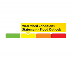
- Flood Outlook – Early notice of the potential for flooding based on weather forecasts, calling for heavy rain, snow melt, high winds or other conditions that could lead to high runoff, cause ice jams and/or lakeshore flooding or erosion.
- Flood Watch – Flooding is possible in specific watercourses or municipalities. Municipalities, emergency services and individuals in flood prone areas should prepare.
- Flood Warning – Flooding is imminent or already occurring in specific watercourses or municipalities.
Flood Outlook: Current Spring Conditions Favourable for Slow Snow Melt Across the Rideau Valley Watershed
March 9, 2020 (WCS – R03/2020) — The winter of 2019-20 has been warmer than average with near-average snowfall amounts. On January 11, about 50 mm of rain fell across the Rideau Valley Watershed, resulting in temporarily elevated water levels and flows in all waterways, and a noticeable ice layer within the snowpack. Current conditions at several RVCA and Parks Canada snow course sites are indicating above average water content amounts in the snow for this time of year.
The current short-term forecast indicates daytime high temperatures above zero and below zero conditions at night with precipitation expected tomorrow (up to 15 mm) and Friday (up to 20 mm). This forecast is favourable for ongoing snow melting. If the temperatures and precipitation come as forecast, much of the snow is expected to melt which will make water levels and flows rise over the coming weeks. This gradual process would result in average flooding this spring across the Rideau Valley watershed with inundation limited to low lying areas along all waterways. However, any significant rain events greater than 25 mm and/or significant temperature increases could influence actual flood conditions as we move through March and into April.
Water levels on lakes and flows in the streams are presently about normal for this time of year. Parks Canada staff who manage the water levels for the Rideau Canal have indicated that the levels will be maintained or lowered in the coming weeks to allow for water storage in the upper watershed lakes as the snowpack continues to melt.
City of Ottawa crews have begun the annual ice removal program on the Rideau River between Rideau Falls and Bronson Avenue. Crews will work to keep the ice from reforming until the spring freshet occurs (for more information: City of Ottawa information at 311).
With the changing levels that can be expected over the coming weeks, ice cover on lakes, ditches, local streams, and rivers will continue to be unstable. Extreme caution should be exercised by everyone when near local waterbodies. Parents should inform their children of the risks and provide appropriate supervision.
Residents in flood-prone or low-lying areas, historically susceptible to flooding, should take the necessary precautions to protect their property, such as:
- Ensuring sump pump is clear, in good working condition and has a backwater valve
- Ensuring easy access to a portable backup generator and pump
- Ensuring downspouts are clear and the outlet is at least 3 metres from the dwelling
- Securing items that might float away as flows increase
- Removing valuable items from basements or lower floors that could be subject to flooding
- Keeping emergency phone numbers handy
- Familiarizing yourself with your municipality’s Emergency Preparedness Plan
This watershed conditions statement is in effect until March 31, 2020, at 5 p.m. and will be updated at that time unless the forecast or conditions change.
"Rideau Valley Conservation Authority is a partnership of municipalities within the Rideau Valley watershed created under the Conservation Authorities Act to deliver a range of programs in watershed management and natural resource conservation."
RVCA Watershed Conditions Statements:
- Water Safety – High flows, unstable banks, melting ice or other factors that could be dangerous for recreational users such as anglers, canoeists, hikers, children, pets, etc. Flooding is not expected.
- Flood Outlook – Early notice of the potential for flooding based on weather forecasts, calling for heavy rain, snow melt, high winds or other conditions that could lead to high runoff, cause ice jams and/or lakeshore flooding or erosion.
- Flood Watch – Flooding is possible in specific watercourses or municipalities. Municipalities, emergency services and individuals in flood prone areas should prepare.
- Flood Warning – Flooding is imminent or already occurring in specific watercourses or municipalities.