Super User
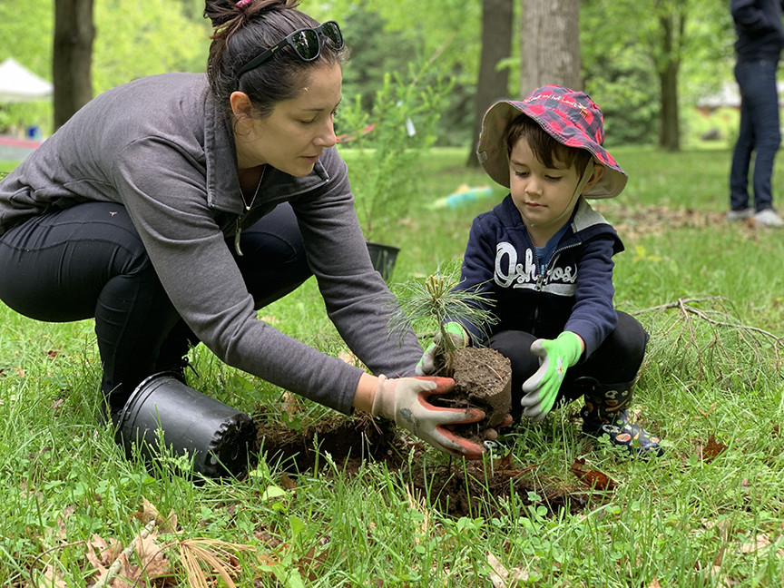
Book it to Baxter to visit new Storybook Trail
MANOTICK, May 2, 2024 – Forests are full of stories, and now Baxter Conservation Area has added another in the form of a permanent Storybook Trail.
Thanks to a generous grant from the TD Friends of the Environment Foundation (TD FEF), a series of displays now dot the popular and accessible Fiddlehead Trail, beginning at the Interpretive Centre. Each case offers a single page of the featured story, allowing families to read together as they move along the trail. Fun activities and challenges that relate to the story also encourage kids to dive deeper into the natural world around them.
“This is such a wonderful addition to our trail network,” said Baxter Site Supervisor Andrea Wood. “Any way we can engage families while getting them outside in nature is a huge win for everyone.”
The Storybook Trail’s first featured book is A Log’s Life by Wendy Pfeffer, which follows the fate of an oak tree that has fallen in a storm. As the giant log slowly returns to the soil, new life springs forth in its place.
“The book ties in perfectly with what kids will see happening in the forest around them as they walk the trails,” Wood said. “It’s another way to spark their curiosity about the natural world.”
The Rideau Valley Conservation Foundation helped facilitate the TD FEF grant after a temporary version of the Storybook Trail was installed during the COVID-19 pandemic to safely engage families on site. It proved extremely popular.
“We are so thankful to TD Friends of the Environment for their ongoing support of our outdoor education programs,” said Foundation Director Diane Downey. “Kids are the future, and our partners are helping us invest in them.”
The Storybook Trail’s featured book will change with the seasons. The trail is open dawn to dusk year-round. Parking is $8 per day or $55 for an annual pass.
Learn more about Baxter Conservation Area and plan your visit: https://www.rvca.ca/conservation-areas/fee-required/baxter
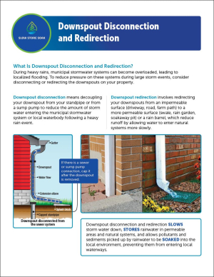
Downspout Disconnection and Redirection

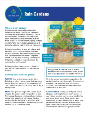
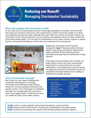
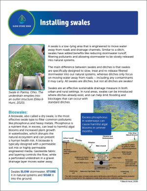
Reducing Our Runoff: Managing Stormwater Sustainably
(WCS – R07/2024)
April 24, 2024 – A Flood Outlook Statement is being maintained for the Upper Rideau Valley Watershed.
Since early April, the Upper Rideau Valley Watershed near Bobs and Christie Lakes and the Tay River has received just over 100mm of rainfall. The weather forecast indicates another 15 to 20mm of precipitation for the next week. This above-average precipitation has resulted in increased water levels in Bobs and Christie Lakes.
Based on the above, a FLOOD OUTLOOK is being maintained for the properties around Bobs and Christie Lakes in the Upper Rideau Valley Watershed. The water levels are expected to remain elevated and may result in flooding for low-lying areas if any significant rainfall events should occur in the coming week(s). Parks Canada staff are closely monitoring the water levels in Bobs Lake and Christie Lake. Operations at the Bolingbroke Dam will take place as required to balance the levels in Bobs Lake and Christie Lake.
Residents in low-lying areas near Bobs and Christie Lakes that are historically susceptible to flooding should take the necessary precautions to protect their property, such as:
- Ensuring sump pump is clear, in good working condition and has a backwater valve
- Ensuring easy access to a portable backup generator and pump
- Ensuring downspouts are clear and the outlet is at least 3 metres from the dwelling
- Securing items that might float away as flows increase
- Removing valuable items from basements or lower floors that could be subject to flooding
- Keeping emergency phone numbers handy
- Familiarizing yourself with your municipality’s Emergency Preparedness Plan
With the elevated conditions, potential exists for further impacts if significant additional rain were to occur before the water levels and flows begin to recede.
Extreme caution should be exercised by everyone when near local waterbodies. Parents should inform their children of the risks and provide appropriate supervision. Pets should be leashed near all bodies of water.
This watershed conditions statement is in effect until Monday, May 6, 2024 at 5 PM unless the forecast or conditions change.
-end-
Contact: Brian Stratton, RVCA Manager Engineering Services
Rideau Valley Conservation Authority
613-692-6804, 1-800-267-3504 ext. 1141
www.rvca.ca/watershed-conditions
"Rideau Valley Conservation Authority is a partnership of municipalities within the Rideau Valley watershed
created under the Conservation Authorities Act to deliver a range of programs in watershed management and
natural resource conservation."
RVCA Watershed Conditions Statements:
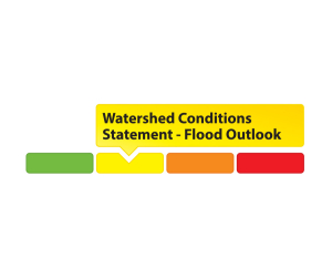
- Water Safety – High flows, unstable banks, melting ice or other factors that could be dangerous for recreational users such as anglers, canoeists, hikers, children, pets, etc. Flooding is not expected.
- Flood Outlook – Early notice of the potential for flooding based on weather forecasts, calling for heavy rain, snow melt, high winds or other conditions that could lead to high runoff, cause ice jams and/or lakeshore flooding or erosion.
- Flood Watch – Flooding is possible in specific watercourses or municipalities. Municipalities, emergency services and individuals in flood prone areas should prepare.
- Flood Warning – Flooding is imminent or already occurring in specific watercourses or municipalities.
Significant Rain in April Causing Elevated Water Levels

(WCS – R06/2024)
April 15, 2024 – A Flood Outlook Statement is being issued for the Upper Rideau Valley Watershed.
Since early April, two large weather systems have brought between 60 to 90 mm of precipitation across the Rideau Valley Watershed. The highest precipitation amounts (90 mm) fell across the Upper Rideau Valley Watershed near Bob’s and Christie Lakes and the Tay River. The weather forecast indicates another 10 to 15 mm of precipitation for the next week.
The significant precipitation received since early April has resulted in increased water levels and flows in all waterways in the Rideau Valley Watershed.
Based on the above, a FLOOD OUTLOOK is being issued for the properties around Bobs and Christie Lakes in the Upper Rideau Valley Watershed. The water levels are expected to exceed full supply levels by this coming weekend and may result in flooding for low-lying areas. Parks Canada staff are closely monitoring the water levels in Bobs Lake and Christie Lake. Operations at the Bolingbroke Dam will take place as required to balance the levels in Bobs Lake and Christie Lake.
Residents in low-lying areas near Bobs and Christie Lakes that are historically susceptible to flooding should take the necessary precautions to protect their property, such as:
- Ensuring sump pump is clear, in good working condition and has a backwater valve
- Ensuring easy access to a portable backup generator and pump
- Ensuring downspouts are clear and the outlet is at least 3 metres from the dwelling
- Securing items that might float away as flows increase
- Removing valuable items from basements or lower floors that could be subject to flooding
- Keeping emergency phone numbers handy
- Familiarizing yourself with your municipality’s Emergency Preparedness Plan
With the elevated conditions, potential exists for further impacts if significant additional rain were to occur before the water levels and flows begin to recede.
Extreme caution should be exercised by everyone when near local waterbodies. Parents should inform their children of the risks and provide appropriate supervision. Pets should be leashed near all bodies of water.
This watershed conditions statement is in effect until Wednesday, April 24, 2024 at 5 PM unless the forecast or conditions change.
-end-
Contact: Brian Stratton, RVCA Manager Engineering Services
Rideau Valley Conservation Authority
613-692-6804, 1-800-267-3504 ext. 1141
www.rvca.ca/watershed-conditions
"Rideau Valley Conservation Authority is a partnership of municipalities within the Rideau Valley watershed
created under the Conservation Authorities Act to deliver a range of programs in watershed management and
natural resource conservation."
RVCA Watershed Conditions Statements:
- Water Safety – High flows, unstable banks, melting ice or other factors that could be dangerous for recreational users such as anglers, canoeists, hikers, children, pets, etc. Flooding is not expected.
- Flood Outlook – Early notice of the potential for flooding based on weather forecasts, calling for heavy rain, snow melt, high winds or other conditions that could lead to high runoff, cause ice jams and/or lakeshore flooding or erosion.
- Flood Watch – Flooding is possible in specific watercourses or municipalities. Municipalities, emergency services and individuals in flood prone areas should prepare.
- Flood Warning – Flooding is imminent or already occurring in specific watercourses or municipalities.