(WCS – R01/2026)
RIDEAU VALLEY, March 3, 2026 – The spring freshet is underway in the Rideau Valley as significant warming and widespread rainfall are forecast for the watershed beginning March 6, 2026. Between March 6 and 8, daytime temperatures are expected to rise well above freezing with limited overnight cooling, which will accelerate snowmelt. Rainfall amounts of 15 to 30 mm are possible and, combined with snowmelt, are expected to generate strong runoff during this period.
Water levels and flows are expected to increase across the entire watershed. Smaller, more responsive watercourses may experience rapid rises. The Rideau River and larger subwatersheds are expected to respond more gradually, with peak levels more likely occurring later next week.
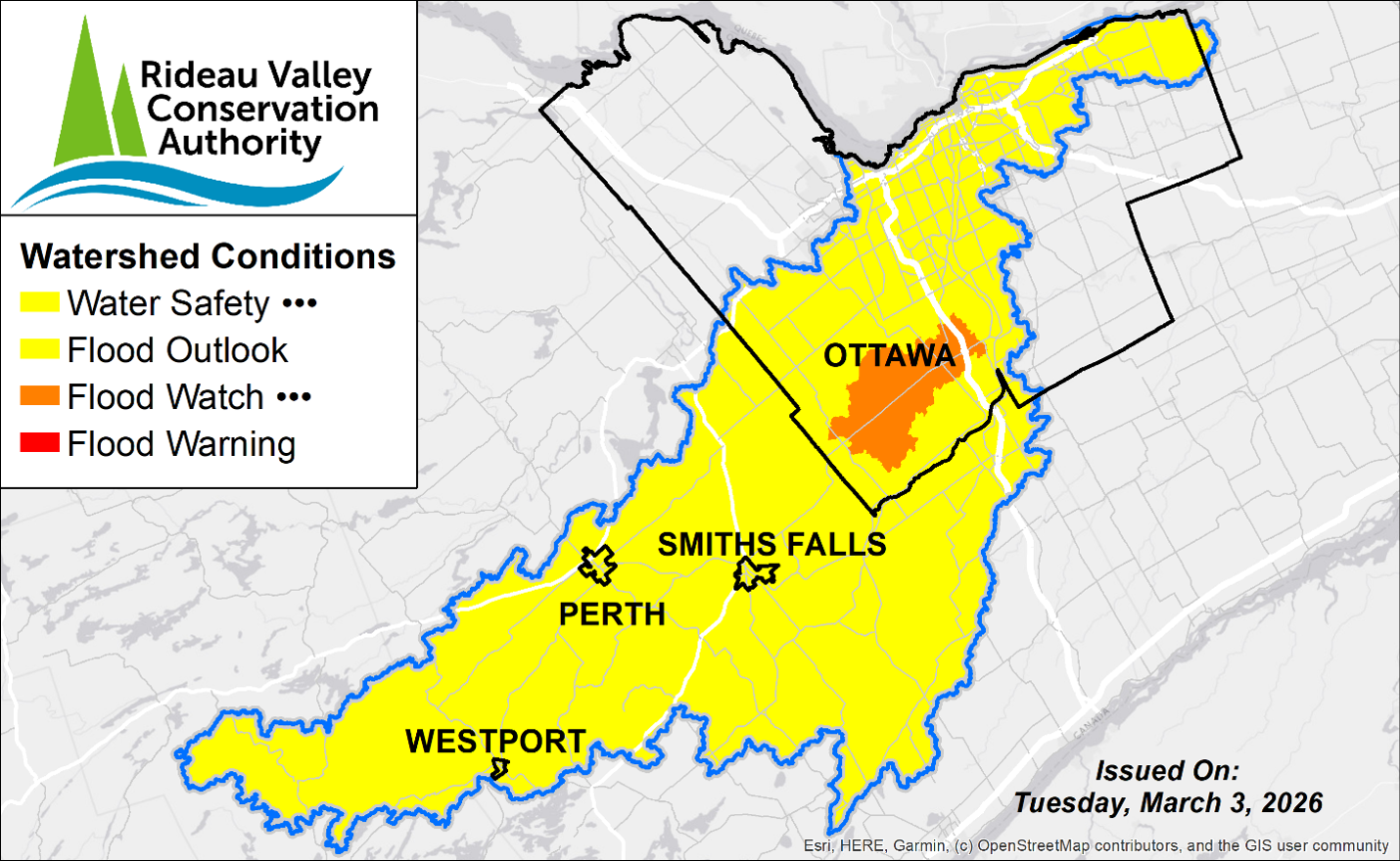
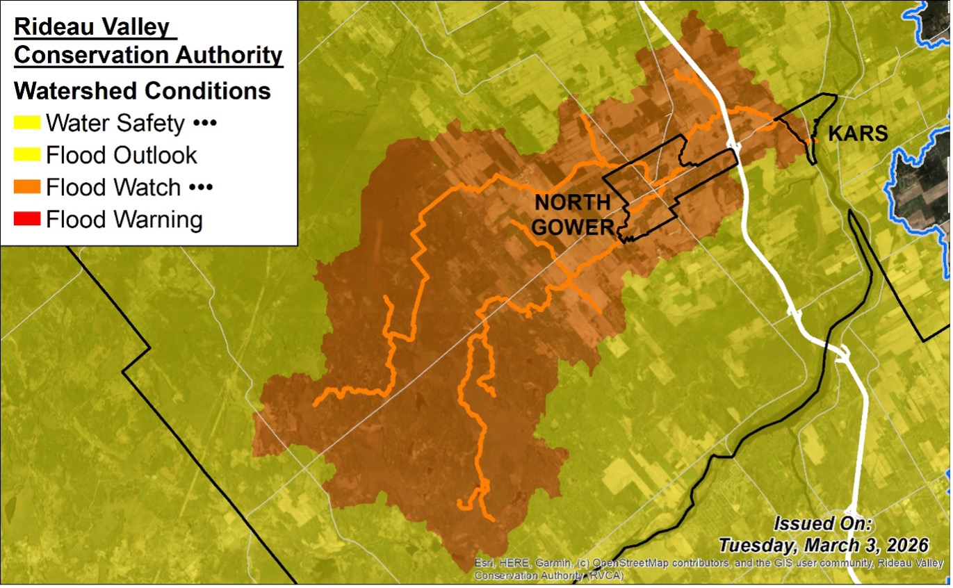
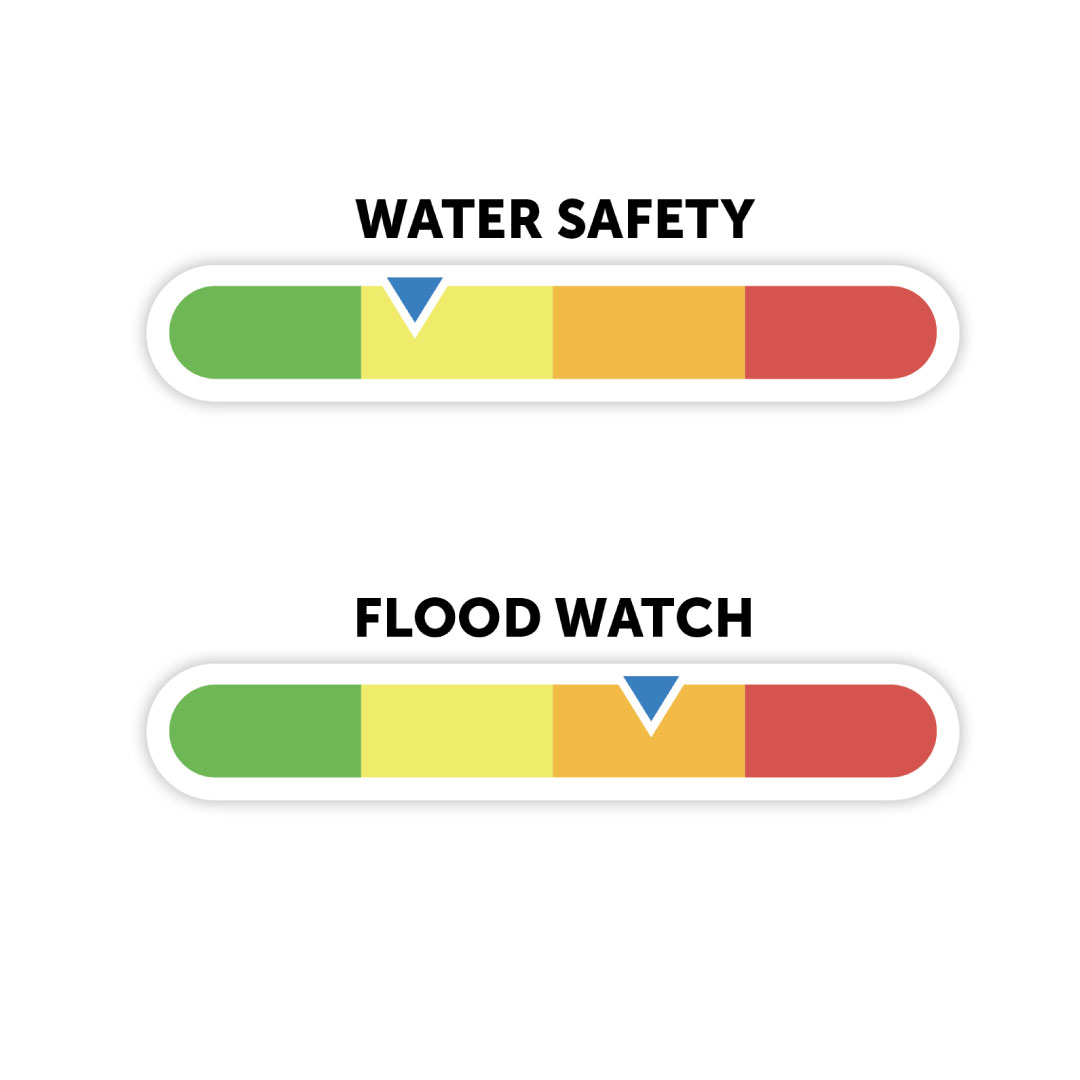
A Water Safety Statement is in effect for the entire watershed. A Flood Watch is being issued for the village of North Gower (Stevens Creek and Taylor Drain), where water levels may approach flooding thresholds between March 6 and 8.
Widespread significant riverine flooding is not anticipated at this time. Localized flooding in low-lying areas remains possible, and rapid melt conditions may increase the risk of ice movement and localized ice jam formation. Conditions will continue to be closely monitored.
More Details:
Weather Forecast: Environment and Climate Change Canada is forecasting significant warming and widespread rainfall leading into the weekend that will impact the Rideau Valley Watershed. Daytime temperatures are expected to rise above freezing, reaching highs of 5 to 14°C from March 6 to March 8, with limited overnight cooling. Rainfall amounts of 15 to 30 mm are possible over the weekend. Forecast guidance suggests that rainfall and snowmelt combined could contribute to strong runoff between March 6 and 8. The long-range forecast indicates a sustained warming trend beyond this timeframe, with continued snowmelt expected into next week. While the exact timing and magnitude of rainfall remains uncertain, conditions are favouring a strong accelerated melt.
Environmental Conditions: Water levels and flows across the Rideau Valley Watershed are currently within the normal seasonal range. Snowpack conditions across the watershed range from normal to slightly elevated within the upper watershed regions. With sustained above-zero temperatures forecast for later this week, snowmelt is expected to increase rapidly. If these warmer temperatures persist, coupled with rainfall, runoff may increase and could produce flooding in low-lying areas, including ditches, stormwater systems, and areas with limited drainage capacity.
Risks: The entire watershed is under a water safety statement with localized areas under a flood watch, with the following risks present:
- The warmer temperatures and rainfall may trigger an accelerated melt, leading to rapid increases in water levels and flows.
- Under rapid melt conditions, existing river ice may weaken and mobilize. The movement of ice can contribute to localized ice jam formation, which can cause sudden water level increases and flooding in vulnerable areas.
- Slippery or unstable banks
- Localized ponding or minor flooding in low-lying areas
Widespread riverine flooding is not anticipated at this time, however runoff conditions may evolve quickly depending on how temperatures and rainfall develop.
Location-Specific Considerations:All water levels and flows across the Rideau
Valley Watershed are expected to increase with possible flooding in low-lying areas,
including ditches and stormwater features. Locations with known ice-related concerns may also experience unstable or shifting ice conditions as temperatures rise.
Rideau River & Major Subwatersheds (Water Safety):
Water levels and flows are expected to increase in response to snowmelt and rainfall through March 6 to 8. Given the size of the watershed, the Rideau River is expected to respond more gradually, with peak levels more likely occurring later next week. Significant widespread flooding is not anticipated at this time. Localized flooding in low-lying areas remains possible.
North Gower – Stevens Creek & Taylor Drain (Flood Watch):
Due to the anticipated rapid melt and possible concurrent rainfall, a flood watch
is being issued for the North Gower region. Water levels and flows in Stevens Creek and the Taylor Drain are expected to rise rapidly from March 6 to March 8, and may possibly exceed flooding onset levels.
Action & Safety Recommendations: Residents are advised to exercise caution when near rivers, streams, and other waterbodies due to the risks summarized above. Parents should inform their children of these dangers and provide appropriate supervision. Residents in flood-prone areas are advised to closely monitor water levels and flows and take the necessary precautions to protect their property, such as:
- Ensuring sump pumps are clear, in good working condition, and have a backwater valve;
- Keeping a portable backup generator and pump easily accessible;
- Ensuring downspouts are clear and directing water at least 3m away from the dwelling;
- Securing items that might float away as water levels rise;
- Removing valuable items from basements or lower floors that could be subject to flooding;
- Keeping emergency phone numbers handy;
- Familiarizing yourself with your municipality’s Emergency Preparedness Plan.
Duration:
- The Water Safety Statement will remain in effect until Thursday, April 30, at 11:59 pm.
- The Flood Watch will remain in effect until Friday, March 13, at 11:59 pm or until an update has been issued.
RVCA monitors water levels and weather forecasts as part of its Flood Forecasting and Warning Program. Updates will be provided as conditions change.
-end-
Newsrooms please note: A Watershed Conditions Statement is NOT a flood warning. Its purpose is to raise public awareness about a change or potential change in watershed conditions.
For more information, contact:
Justin Robert
Flood Duty Officer
1-800-267-3504 ext. 1194
RVCA Watershed Conditions Statements:
Water Safety – High flows, unstable banks, melting ice or other factors that could be dangerous for recreational users such as anglers, canoeists, hikers, children, pets, etc. Flooding is not expected.
Flood Outlook – Early notice of the potential for flooding based on weather forecasts, calling for heavy rain, snow melt, high winds or other conditions that could lead to high runoff, cause ice jams and/or lakeshore flooding or erosion.
Flood Watch – Flooding is possible in specific watercourses or municipalities. Municipalities, emergency services and individuals in flood prone areas should prepare.
Flood Warning – Flooding is imminent or already occurring in specific watercourses or municipalities.