Oct 08, 2025 - Due to persistent rainfall deficits, diminished baseflows and above average temperatures, the Rideau Valley Water Response Team is maintaining a Level 3 Low Water Advisory for the Rideau Valley Watershed after officials met to discuss conditions.
Level 3 conditions are triggered when rainfall deficits fall below 40% of the long-term average and/or when streamflows decline to severe low-water thresholds (typically below the 10-year return period low flow).
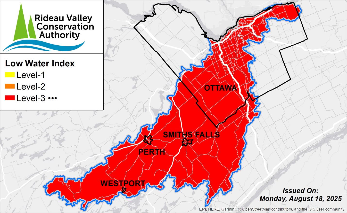
A Level 3 low water advisory is not a declaration of an emergency, but an indicator of significant dry conditions and impacts observed across the Rideau Valley watershed.
The Rideau Valley Conservation Authority provides science-based advice and coordination during low water conditions but does not have the authority to enforce water use restrictions. Decisions related to restrictions or bylaws rest with individual municipalities and provincial agencies.
Historical Norms
The fall season is typically a crucial annual period where our surface water and groundwater systems are replenished. The cooler conditions, reduced plant-use of water, and consistent rainfall typically allow our soils and the underlying groundwater aquifers to be replenished. Under normal conditions, the region would receive between 80-100 mm of rain each month during the fall, contributing to gradual aquifer replenishment, which leads to subsequent baseflow* recovery.
*baseflow is the long-term sustained flow in a stream or river that comes from seepage out of our groundwater aquifers.
Current Conditions
Rainfall and streamflow conditions from July through to October have remained significantly below normal, with strong persistent deficits noted across the region. In addition, no clear signs of typical groundwater aquifer replenishment have been observed at select wells in the local groundwater monitoring network.
Rainfall
- Looking ahead, the 10-day Environment Canada forecast shows only limited precipitation, with total accumulations of 2–4 mm expected across the region. 90-day totals across the watershed are 40%–60% of the long-term average for this time of year
- 30-day totals are of particular concern, with most areas receiving less than 35% of normal rainfall.
Streamflow & Baseflow
- Streamflow and water levels have diminished significantly across all Rideau Valley subwatersheds
- Severely reduced to absent baseflows have resulted in prolonged critical low flow conditions in both Kemptville Creek and the Jock River, with several reaches now highly fragmented or disconnected.
- Kemptville Creek has experienced persistent periods of near-zero flow, with only brief fluctuations in response to minor rainfall events. Current conditions represent the lowest sustained flows on record (1969–present).
Groundwater
- Data from the Provincial Groundwater Monitoring Network indicate sustained and continuous declines in groundwater levels across the region, with select wells reaching new record lows within their 20- to 25-year period of record.
Navigation & Reservoir Levels
Parks Canada has advised that, due to ongoing dry conditions and limited rainfall, water levels along the Rideau Canal are expected to drop below navigation draft requirements shortly after the close of the 2025 navigation season on October 14. Water levels may recede more quickly than usual in reaches between Long Island and Burritts Rapids, Clowes and Merrickville, Merrickville and Kilmarnock, and Kilmarnock and Edmonds. The Parks Canada’s water management team continues to monitor conditions closely and will adjust operations as needed.
For further information, please contact:
Water levels within the upper watershed lakes and reservoirs remain below the long-term average. Following the close of the navigation season, outflows will be gradually reduced to operational minimums to conserve upstream storage and mitigate further declines in lake and downstream river levels.
Recommended Actions
Limited rainfall and groundwater recharge have: caused an unusual lowering of the groundwater table; and reduced the baseflow that normally sustains our streams and rivers through late summer, fall, and winter. Although these conditions are natural, rather than the result of excessive human use, responsible water use remains important for mitigating further stress on the systems.
By lessening water use, users help sustain existing aquifer volumes, reduce pressures on shallow private wells and on our lakes, wetlands, streams, and rivers, until typical conditions return.
Permit Holders
Holders of Permits to Take Water from surface or groundwater sources are strongly encouraged to reduce use, wherever possible. During low flow conditions, large surface & groundwater takings can significantly impact local water availability.
Private Wells
Residents that rely on groundwater wells are encouraged to use water efficiently to help protect the shared aquifer system. Areas that rely on the shallow groundwater system are particularly vulnerable and already experiencing significant shortages. However, water conservation measures is also important for residents using deeper aquifers, as these systems are often connected to the shallower systems and parts of our surface water systems.
In Ontario, private wells are managed by their owners with some regulatory support from the province. Those experiencing well performance or groundwater level issues can consider the following actions.
- seek advice from the Ontario “Wells Help Desk” (Wells on your property | ontario.ca) (Ontario Ministry of the Environment, Conservation and Parks)
- seek assistance from a licensed well contractor, which includes many plumbers based in rural areas.
- consult with your municipality about possible bulk water supply services
- consult the provincial reference:Managing Your Water Well In Times Of Water Shortage: https://www.ontario.ca/page/managing-your-water-well-times-water-shortage
Municipal Surface and Groundwater Systems
Residents connected to municipal water supplies should monitor their municipality’s official channels for updates on water use restrictions.
Urban Ottawa
Residents served by the City of Ottawa’s central drinking water system are not subject to the same water supply pressures, as this system draws from the Ottawa River.
General Advisories
All residents are encouraged to follow municipal updates for guidance on water conservation, water source conditions, and information on fire bans.
Conservation Authority staff continue to monitor conditions and communicate with water managers throughout the watershed. Updates to this message will be issued as conditions warrant.
More resources:
Ministry of Environment, Conservation and Parks - Wells Help Desk: https://www.ontario.ca/page/wells-your-property#section-4
Ministry of Environment, Conservation and Parks – Find a Licensed Well Contractor: https://www.ontario.ca/page/find-licenced-well-contractors
Ministry of Environment, Conservation and Parks – Managing Your Water Well In Times Of Water Shortage: https://www.ontario.ca/page/managing-your-water-well-times-water-shortage
Ontario’s Low Water Response program: https://www.ontario.ca/page/low-water-response-program.
City of Ottawa Dry Conditions Webpage: https://www.ottawa.ca/en/health-and-public-safety/emergency-preparedness/current-and-ongoing-emergencies/dry-conditions
RVCA website: www.rvca.ca
Hourly and daily streamflows and water levels: https://www.rvca.ca/watershed-management/streamflow-and-water-levels

For more information, contact:
Isabelle Maltais
Director, Watershed Science & Engineering
1-800-267-3504 ext. 1165
"Rideau Valley Conservation Authority is a partnership of municipalities within the Rideau Valley watershed created under the Conservation Authorities Act to deliver a range of programs in watershed management and natural resource conservation."
RVCA Watershed Low Water Conditions Statements:
LEVEL I: There is minor concern. 80% to 60% of long-term average precipitation for 540 day and/or 90 day precipitation totals and/or 7-day average streamflows are less than the 5-year return period low flow.
LEVEL III: There is a failure of the water supply to meet demand. Less than 40% of long-term average precipitation for 540, 90 and/or 30 day precipitation totals and/or 7-day average streamflows are less than the 10-year return period low flow.
LEVEL II: There is a potentially serious problem pending. 60% to 40% of long-term average precipitation for 540, 90 and/or 30 day precipitation totals and/or 7-day average streamflows are less than the 10-year return period low flow.