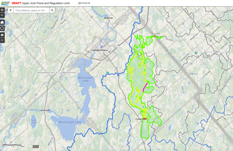
BECKWITH TOWNSHIP, Nov. 10, 2021 — The Rideau Valley Conservation Authority (RVCA) is asking for public input on a new hazard mapping study for the Jock River in Beckwith Township.
The study considers the risk of flooding, erosion and other hazards from Ashton Station Road to approximately the south limit of the community of Franktown. Members of the public are invited to review the draft regulation and hazard maps during the public consultation period between November 15 to December 22, 2021.
The new mapping shows areas that are subject to natural hazards such as flooding and unstable slopes or that have natural environmental features such as wetlands. The mapping will be used by Beckwith Township when updating its Official Plans and Zoning Schedules and in the review of development applications under the Planning Act. RVCA will also use the mapping to guide the review of development applications submitted under the RVCA’s Development, Interference with Wetlands and Alterations to Shorelines and Watercourses Regulation.
The goal of this mapping is to help ensure sound planning decisions are made — keeping people and property safe. Accurate engineered hazard mapping is the foundation of effective floodplain and resource management. This is the first time this section of the Jock River has been hazard mapped.
Members of the public are encouraged to review the draft mapping (available online at www.rvca.ca/upper-jock) and connect with an RVCA Resource specialist to understand how the mapping may affect their property. Due to COVID-19, we are not holding an in-person public open house. Instead, we invite you to contact an RVCA Resource Specialist via:
Individual or small group meetings on-line or in person can also be booked to discuss local impacts and concerns.
Conservation Authority staff also welcome local input on the mapping, including historical records of past flood events, slope failures, erosion, news clippings, photographs and even anecdotal stories to help confirm the reasonableness of calculations and resulting hazard mapping.
This study is just one of several ongoing hazard mapping studies taking place in the watershed. For a complete list of ongoing work, please visit www.rvca.ca. Learn more about the hazard mapping process in this short video: