OTTAWA, March 30, 2022 – Public consultation on the draft hazard mapping study for Stevens Creek from Malakoff Road to the Rideau River will continue until April 29, 2022.
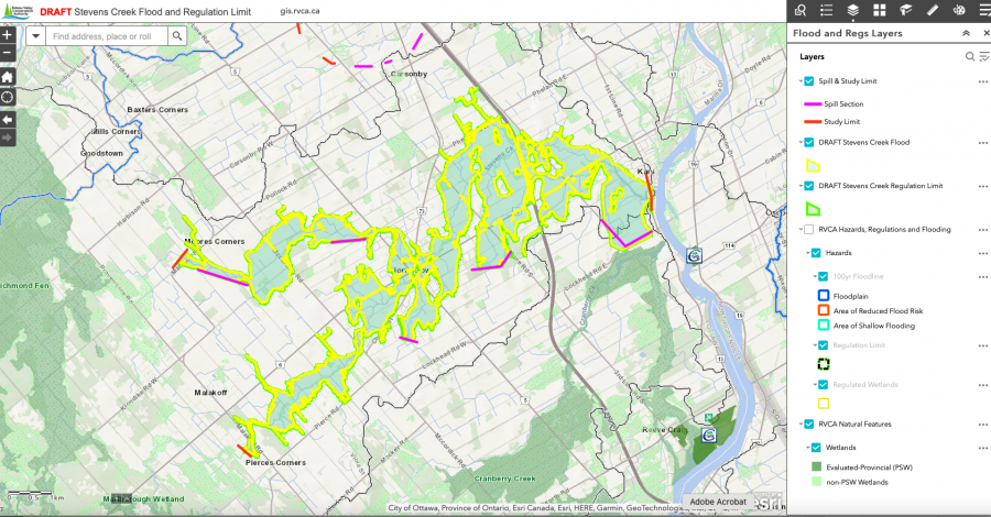
The Rideau Valley Conservation Authority (RVCA), in collaboration with the City of Ottawa, has completed a hazard mapping study for Stevens Creek from Malakoff Road to the Rideau River. Virtual public consultation began late November 2021. Affected landowners were notified by mail and staff have been responding to inquiries by telephone calls, e-mail, virtual meetings, small group in-person meetings and site visits. In some cases the draft mapping has been refined based on site-specific information.
With the recent easing of provincial COVID-19 restrictions, the RVCA is now able to host an in-person presentation and question and answer session to provide an additional opportunity for public consultation.
Thursday, April 21, 2022
Alfred Taylor Recreation Centre
2300 Community Way, North Gower
Doors Open at 6:00 p.m.
Presentation begins at 6:15 p.m.
Question & Answer period to follow
Anyone unable to attend can contact an RVCA Resource at 613-692-3571, toll-free at 1-800-267-3504 or by email at . Additional information is also available on our website at www.rvca.ca/stevens-creek.
The new mapping shows areas that are subject to natural hazards such as flooding and unstable slopes or have important natural features such as wetlands. The goal of this mapping is to help ensure sound land use planning, development and resource management decisions are made that protect people and property.
Once approved, the mapping will be used by the City of Ottawa when updating its Official Plan and Zoning Schedules and in the review of development applications under the Planning Act. RVCA will also use the mapping to guide the review of development applications submitted under the RVCA’s Development, Interference with Wetlands and Alterations to Shorelines and Watercourses Regulation.
This study is being done through a collaboration involving the City of Ottawa and the Rideau Valley, Mississippi Valley and South Nation Conservation Authorities. The City recognized a need to update its zoning schedules based on up-to-date hazard mapping and has provided contributions enabling the Conservation Authorities to move ahead with these studies sooner than would otherwise be possible. For a complete list on ongoing work, please visit www.rvca.ca.
-30-