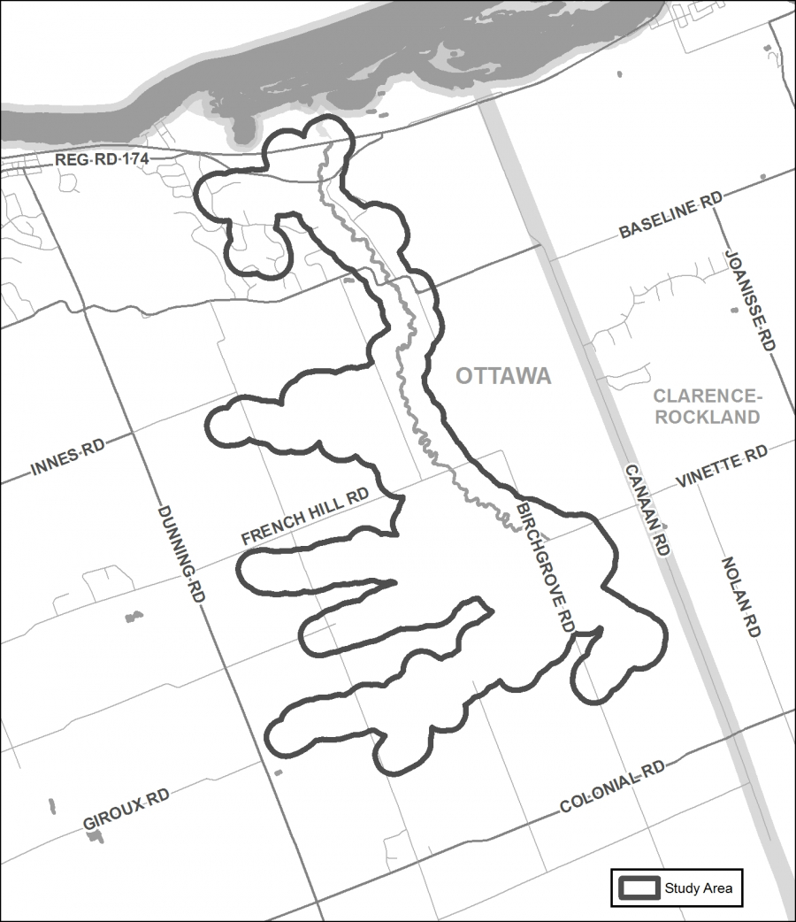
CITY OF OTTAWA, November 14, 2018 — The Rideau Valley Conservation Authority (RVCA) has completed a hazard mapping study for Becketts Creek from the Sarsfield Road to Ottawa River. Members of the public are invited to an upcoming open house to review regulation and hazard maps.
The new mapping shows areas that are subject to natural hazards such as flooding and unstable slopes and have natural environmental features such as wetlands. The mapping will be used by the City of Ottawa when updating its Official Plans and Zoning Schedules and in the review of development applications under the Planning Act. RVCA will also use the mapping to guide the review of development applications submitted under the RVCA’s Development, Interference with Wetlands and Alterations to Shorelines and Watercourses Regulation.
The goal of this mapping is to help ensure that sound planning decisions are made — keeping people and property safe. Accurate engineered hazard mapping is the foundation of effective floodplain and resource management.
Members of the public are encouraged to attend the open house and/or provide comments on the mapping. Conservation Authority staff welcome historical records of past flood events, slopes failures, erosion, news clippings, photographs and even anecdotal stories to help confirm the reasonableness of calculations and resulting hazard mapping.
Becketts Creek Regulations and Hazard Land Mapping Study Public Open House
Tuesday, December 4, 2018
4:30 to 8:00 p.m.
R.J. Kennedy Memorial Community Center, Hall A
1115 Dunning Road, Cumberland
For those unable to attend the open house, mapping can also be seen online at www.rvca.ca/becketts-creek. To understand how mapping may affect your property or to provide comments, please contact an RVCA Resource Specialist at or complete an online property inquiry form at www.rvca.ca/ general-property-inquiries.
This study is being done through a collaboration involving the City of Ottawa and the Rideau Valley, Mississippi Valley and South Nation Conservation Authorities. The City recognized a need to update its zoning schedules based on up-to-date hazard mapping and has provided contributions enabling the Conservation Authorities to move ahead with these studies sooner than would otherwise be possible. The RVCA is currently working on several studies in the Ottawa area. For a complete list on ongoing work, please visit www.rvca.ca.