
Super User
RIDEAU VALLEY, April 22, 2021 – Just in time for Earth Day, Rideau Valley residents can count on cleaner water, healthier shorelines and more climate-resilient communities thanks to a groundbreaking agreement between the Rideau Valley Conservation Foundation (RVCF) and Modern Niagara.
The national mechanical, electrical, integrated technology and building services corporation will provide $300,000 to the Foundation over five years to help acquire 375 more acres of local wetlands, shorelines and forests for perpetual protection.
This is the first deal of its kind for the RVCF and will provide it with much more flexibility to acquire sensitive natural areas across the watershed.
The agreement also kickstarts Modern Niagara’s journey to carbon neutrality by protecting lands that naturally absorb and store carbon dioxide. The company is working on other strategies to reduce its carbon footprint, as well.
The land deal safeguards vital environmental services for nearby communities.
“This agreement is a huge win for the watershed’s residents, who rely on robust wetland and forest cover to provide flood, drought and erosion control and to keep our air and water clean,” said Diane Downey, executive director of the RVCF. “Protecting pristine natural areas is our first and best defence against the impacts of climate change.”
The RVCF currently owns, manages or supports more than 6,765 acres of unique, healthy ecosystems across the Rideau Valley. But these lands cost money to acquire and maintain; surveys, appraisals, legal fees, property taxes and public safety measures are all expenses the Foundation accepts when it acquires a property.
The Foundation’s Steve Simmering Conservation Lands Endowment Fund is used to cover these costs, with the principal invested year after year to create a steady flow of cash. But until this agreement, the endowment required more principal to offset all of the annual and acquisition costs.
Today, thanks to Modern Niagara, the Foundation won’t have to say no to future land donations. The agreement gives the Foundation the flexibility and financial security to accept new lands, by covering the many land transfer costs that can add up.
“Modern Niagara is proud to preserve our most sensitive natural areas while also doing our part to slow the impacts of climate change,” said Erin Oliver, Modern Niagara’s VP of Health, Safety and Sustainability. “Green and sustainable technology is at the core of what we do, and you can’t find a greener technology than allowing nature to do its work.”
Oliver said the Modern Niagara team is thrilled to be protecting local lands that have a direct impact on the health and sustainability of their communities.
“We are so excited for this partnership and can’t wait to see what beautiful parcels of local land will be protected because of it,” Oliver said.
Want to get on board?
The RVCF welcomes corporations and organizations of all sizes to become a local environmental champion like Modern Niagara and our other legacy partners like LiVE 88.5 FM by sponsoring a property, supporting local tree planting, helping to upgrade our nature trails, supporting outdoor education opportunities or through their own visionary idea.
Whatever your budget, we can work with you to find a method of support that suits your vision while keeping our watershed clean and healthy for generations to come.
Visit www.rvcf.ca for more information or contact Diane Downey at to get started.
-30-
Amber Blewitt (on leave)
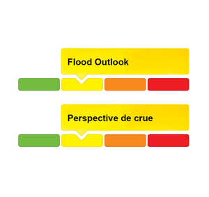
Flood Outlook — Lower Ottawa River | Perspective de crue – Cours inférieur de la rivière des Outaouais
Water Conditions Statement: Flood Outlook — Lower Ottawa River
March 26, 2021 — A Flood Outlook Statement is being issued for areas along the Lower Ottawa River. Based on current snow cover and weather forecast, it is anticipated that levels and flows along the main stem of the river from Arnprior to Hawkesbury are expected to begin to rise over the next few days but will remain within the normal range of fluctuations associated with the spring freshet period.
Presently, the snow cover varies significantly across the 146,300 square kilometre Ottawa River basin, with some areas in the south of the basin having no snow cover at all. Where there is snow cover, the snow water content (amount of water contained in the snow) is lower than average over much of the basin except in the west-central portion of the basin where average conditions prevail. Snow water content is only one of several factors impacting the magnitude of the spring freshet each year.
The Ottawa River Regulating Committee indicates that with the current weather forecast, flooding in low-lying areas is not expected to occur over the next few days. Levels are currently expected to remain below flood thresholds. While it is not possible to completely rule out the occurrence of a large spring freshet, the factors that are known at this time, namely below average snow water content in all locations and an early spring start, are positive indicators of a year without excessive flooding along the Ottawa River.
Throughout the freshet period, the combination of heavy rainfall and snowmelt may result in rapid increases in water levels and flows on the main stem of the Ottawa River from Mattawa down to the Montreal Region.
Residents in flood-prone areas are encouraged to closely follow evolving conditions and to take necessary measures. Residents are advised to stay away from watercourses where flows are high and where banks might be unstable. Parents are encouraged to explain dangers to children.
The Mississippi Valley, Rideau Valley, and South Nation Conservation Authorities monitor water levels and weather forecasts with the Ministry of Natural Resources and Forestry as part of the Flood Forecasting and Warning Program. Updates are provided as conditions change.
The Ottawa River Regulating Committee will be reassessing forecast conditions and providing hydrological condition updates on its website daily at ottawariver.ca/forecasts/.
To view current flood warnings across Ontario, visit: www.ontario.ca/law-and-safety/flood-forecasting-and-warning-program.
This FLOOD OUTLOOK STATEMENT is in effect until April 16, 2021 at 5:00 PM.
- end -
Definitions:
- Water Conditions Statement: Water Safety: indicates that high flows, melting ice or other factors could be dangerous for such users as boaters, anglers and swimmers but flooding is not expected.
- Water Conditions Statement: Flood Outlook: gives early notice of the potential for flooding based on weather forecasts calling for heavy rain, snow melt, high winds or other conditions.
- Flood Watch: potential for flooding exists within specific watercourses and municipalities.
- Flood Warning: flooding is imminent or occurring within specific watercourses and municipalities.
Communiqué sur les conditions du bassin versant : Perspective de crue – Cours inférieur de la rivière des Outaouais
Le 26 mars 2021 — Un communiqué de perspective de crue est émis pour les régions situées le long du cours inférieur de la rivière des Outaouais. D'après la couverture de neige actuelle et les prévisions météorologiques, on prévoit que les niveaux et les débits le long du tronçon principal de la rivière, d'Arnprior à Hawkesbury, devraient commencer à augmenter au cours des prochains jours, mais resteront dans la plage normale des fluctuations associées à la période de crue printanière.
À l'heure actuelle, la couverture de neige varie considérablement dans le bassin de la rivière des Outaouais d'une superficie de 146 300 km², certaines régions du sud du bassin n'ayant aucune couverture de neige. Là où il y a une couverture de neige, la teneur en eau de la neige (quantité d'eau contenue dans la neige) est inférieure à la moyenne dans la majeure partie du bassin, sauf dans la partie centrale ouest du bassin où les conditions sont moyennes. La teneur en eau de la neige n'est qu'un des nombreux facteurs qui influent sur l'ampleur de la crue printanière chaque année.
Le Comité de régularisation de la rivière des Outaouais indique qu'avec les prévisions météorologiques actuelles, on ne prévoit pas d'inondation dans les basses terres au cours des prochains jours. On s'attend actuellement à ce que les niveaux demeurent sous les seuils d'inondation. Bien qu'il ne soit pas possible d'exclure complètement l'occurrence d'une grande crue printanière, les facteurs connus à l'heure actuelle, à savoir une teneur en eau de la neige inférieure à la moyenne dans tous les endroits et un début de printemps précoce, sont des indicateurs positifs d'une année sans inondation excessive le long de la rivière des Outaouais.
Tout au long de la période de crue printanière, la combinaison de fortes pluies et de fonte des neiges peut entraîner une augmentation rapide des niveaux d'eau et des débits sur le cours principal de la rivière des Outaouais, de Mattawa jusqu'à la région de Montréal.
Les résidents des zones sujettes aux inondations sont invités à suivre de près l'évolution des conditions et à prendre les mesures nécessaires. Il est conseillé aux résidents de ne pas s'approcher des cours d'eau où le débit est élevé et où les berges peuvent être instables. On recommande aux parents d'expliquer les dangers aux enfants.
Les offices de protection de la nature des rivières Mississippi, Rideau et Nation Sud surveillent les niveaux d'eau et les prévisions météorologiques avec le ministère des Richesses naturelles et des Forêts dans le cadre du programme de prévision et d'alerte des crues. Des mises à jour sont émises en fonction de l'évolution des conditions.
Le Comité de régularisation de la rivière des Outaouais réévaluera les prévisions et publiera quotidiennement des mises à jour des conditions hydrologiques sur son site Web à ottawariver.ca/forecasts/. Pour consulter les alertes de crue actuelles en Ontario, visitez le site : www.ontario.ca/law-and-safety/flood-forecasting-and-warning-program.
Ce COMMUNIQUÉ DE PERSPECTIVE DE CRUE est en vigueur jusqu'au 16 avril 2021 à 17 h.
- fin -
Définitions :
- Communiqué sur les conditions des bassins versants – Sécurité aquatique : indique que des débits forts, de la glace fondante ou d’autres facteurs peuvent être dangereux pour des utilisateurs comme les plaisanciers, les pêcheurs à la ligne et les baigneurs, mais qu’une crue n’est pas prévue.
- Communiqué sur les conditions des bassins versants – Perspective de crue :préavis de crue possible basé sur des prévisions de pluies abondantes, de fonte des neiges, de forts vents ou autre.
- Veille de crue :possibilité de crue pour des cours d’eau et municipalités spécifiques.
- Avertissement de crue : crue immimente ou en cours pour des cours d’eau et
municipalités spécifiques.
Rain in Forecast Will Cause Water Levels to Increase Again Across the Rideau Valley Watershed
March 25, 2021 - Above normal temperatures in March have melted most of the snow across the Rideau Valley watershed. The snow melt was quite rapid at first causing water levels and flows to rise quickly in some areas. This was followed by a more gradual melt of the remaining snow. For the most part, water levels and flows are about normal for this time of year and are well below flood thresholds.
The short-term forecast is calling for rainfall amounts of between 40 to 50 millimetres between Thursday and Sunday, with heaviest rain on Friday, and cooler temperatures but still above zero. If the rain comes as forecast, water levels and flows will increase again across the Rideau Valley Watershed. As such, an updated FLOOD OUTLOOK is in effect due the possibility of flooding for all low-lying areas along all waterways, especially near small creeks and streams. Parks Canada staff who manage the water levels for the Rideau Canal have indicated that the levels in the upper watershed lakes are currently below average and expected to rise but not to flood levels.
Further to the above, a FLOOD WATCH is in effect for the low-lying areas along Stevens Creek and Taylor Drain in the Village of North Gower. If the rain comes as forecast, water levels may be similar too, or possibly higher than, those already observed this spring.
With the rising water levels expected over the coming days, the remaining ice cover on lakes, ditches, local streams, and rivers will be unstable. In addition, ice cover in the rivers and streams may breakup as a result of warm temperatures and higher flows, increasing the risk of ice jams and associated overbank flooding. Extreme caution should be exercised by everyone when near local waterbodies. Parents should inform their children of the risks and provide appropriate supervision.
Residents in flood-prone or low-lying areas, historically susceptible to flooding, should take the necessary precautions to protect their property, such as:
- Ensuring sump pump is clear, in good working condition and has a backwater valve
- Ensuring easy access to a portable backup generator and pump
- Ensuring downspouts are clear and the outlet is at least 3 metres from the dwelling
- Securing items that might float away as flows increase
- Removing valuable items from basements or lower floors that could be subject to flooding
- Keeping emergency phone numbers handy
- Familiarizing yourself with your municipality’s Emergency Preparedness Plan
This watershed conditions statement is in effect until April 15, 2021, at 5 p.m. and will be updated at that time unless the forecast or conditions change.

RIDEAU VALLEY, March 19, 2021 – Even the goodest of good pups can accidentally harass or kill wildlife while off exploring, which is why we’re reminding visitors to keep their dogs on-leash and on conservation area trails at all times.
Spring is a particularly sensitive time, as some birds and animals build their nests on or very close to the ground. These nests can easily be trampled, eaten or otherwise destroyed by curious canines.
While we welcome on-leash dogs to most of our conservation areas, RVCA's Conservation Lands manager Chelsey Ellis says her department’s top priority is protecting the natural spaces the RVCA owns and manages.
“Off-leash dogs disrupt the ecosystems we are trying to protect,” Ellis said. “We want to ensure we can balance all the unique natural activities happening at our sites. Guest can do their part to help by keeping dogs on-leash while they connect with nature.”
The meadowlark, bobolink and whip-poor-will are all considered species at risk in Ontario, and all of them build their nests on the ground, making them vulnerable to roaming pups. Game animals like grouse, ducks and turkeys also nest on the ground. Mammals like mice, voles, chipmunks and even skunks can also be found cuddled up with their young in burrows, under logs, in leaf litter or in cavities at the base of trees where they are at risk of being disturbed.
Allowing pups to poop in the woods where it’s not easily cleaned up is a problem, too, as dog poop can contaminate nearby waterways and introduce disease and parasites to local wildlife. Cleaning up after your dog – on or off the trail – is essential to protecting our natural areas and waterways.
The RVCA operates 11 conservation areas across the watershed, including 42 kilometres of trails. Our properties include wetlands and forests, unique floodplain lands along the Rideau River and a wildlife reserve in Perth. Please note the wildlife reserve does not allow any dogs at any time.
To plan your visit, see www.rvca.ca/conservation-areas.
-30-
Team of super sleuths help RVCA investigate Adrains Creek
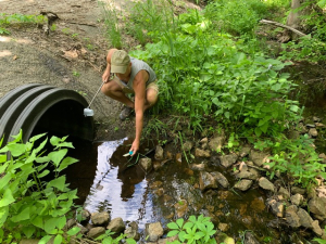
RIDEAU LAKES, March 15, 2021 – Holmes and Watson would surely approve of the watershed’s latest investigative team: the Township of Rideau Lakes, Upper Rideau Lake Association (URLA) and the Rideau Valley Conservation Authority (RVCA).
This spring, staff and volunteers from all three organizations will embark on their second season of a unique collaboration to examine why water quality in Adrains Creek is consistently rated “poor” in RVCA reports – and whether the creek is contributing to the same poor rating in Upper Rideau Lake.
RVCA regularly monitors sites throughout Upper Rideau Lake and one site on Adrains Creek. The township contributed funding to support additional sampling last summer, and URLA supplied funding and two volunteers.
“This is a new type of project for us,” said RVCA’s surface water quality co-ordinator Sarah MacLeod-Neilson, who organized the program. “We’re excited for more collaborations like this. We want to work with our municipalities, lake associations and other local partners to identify and address specific problem areas.”
Adrains Creek was identified as having poor water quality in a 2014 subwatershed report because of high concentrations of nutrients, metals and bacterial counts, but it was unclear whether that was due to natural causes, a one-off event or upstream land uses.
Malcolm Norwood, then the township’s acting manager of development services, said this kind of investigation helps the municipality make better planning decisions.
“The more detailed information we can get, the easier it is to go to Council and say, ‘Here’s the problem and here are some policy options to rectify it,’” Norwood said. “Being able to partner with the RVCA and use their expertise helps us understand these acute problems to enact better policies.”
Dave Counter was one of two URLA volunteers who provided his time and a boat to get samples to the RVCA while working within strict public health measures last summer. The idea was that he and fellow volunteer Ena Shaw would sample the creek during big rain events, but the 2020 summer was so dry it almost never happened.
Instead, Counter and Shaw took standing water samples ever few weeks and sent MacLeod-Neilson photos of the creek’s general status.
Counter and Shaw also tested lake water in McNally’s Bay and at the mouth of the creek to determine if the creek’s water quality was impacting the lake. Results showed no evidence that it was, largely due to the lack of water flow in the system.
Despite last year’s efforts, no definitive cause for the creek’s poor quality was unearthed. With the mystery still to be solved, all parties have agreed that more monitoring is needed in 2021. Counter has already committed to continue sampling this spring and summer – hopefully with more rain events to get the flow data they need.
“I told the RVCA if they needed any help solving this mystery, we would provide it,” Counter said.
As for MacLeod-Neilson, she said she’s impressed with the dedication of RVCA’s volunteers and the interest from member municipalities to protect and improve water quality in the Rideau Valley.
“We’re truly grateful to all of our partners,” she said.
To learn more about RVCA water quality monitoring and for information about your subwatershed, visit watersheds.rvca.ca.
-30-
Spring Outlook: Early Snow Melt and Rising Water Levels Expected Across the Rideau Valley Watershed

WCS – R03/2021
March 8, 2021 –The winter of 2020-21 is quickly coming to an end. After a mild start, February brought cooler temperatures. The watershed saw a significant rain event in late December, followed by below normal precipitation in January and above normal precipitation in February. Current conditions recorded at several RVCA and Parks Canada snow course sites are indicating normal water content amounts in the snow for this time of year. In general, water levels on lakes and flows in the streams are presently below normal for this time of year.
The current short-term weather forecast indicates a warm week ahead with daytime high temperatures well above zero from Tuesday through at least next weekend and night-time low temperatures also above zero on Wednesday and Thursday. The forecast indicates some but no significant precipitation this week.
If the temperatures come as forecast, a significant amount of the snow is expected to melt across the Rideau Valley watershed which will make water levels and flows rise quickly and may result in flooding for low lying areas along all waterways, especially near small creeks and streams. Parks Canada staff who manage the water levels for the Rideau Canal have indicated that the levels in lakes are expected to rise in the upper watershed lakes as the snowpack begins to melt.
City of Ottawa crews have begun the annual ice removal program on the Rideau River between Rideau Falls and Bronson Avenue. Crews will work to keep the ice from reforming until the spring freshet occurs (for more information: City of Ottawa information at 311).
With the rising water levels that can be expected over the coming weeks, ice cover on lakes, ditches, local streams, and rivers will be unstable. Extreme caution should be exercised by everyone when near local waterbodies. Parents should inform their children of the risks and provide appropriate supervision.
Residents in flood-prone or low-lying areas, historically susceptible to flooding, should take the necessary precautions to protect their property, such as:
- Ensuring sump pump is clear, in good working condition and has a backwater valve
- Ensuring easy access to a portable backup generator and pump
- Ensuring downspouts are clear and the outlet is at least 3 metres from the dwelling
- Securing items that might float away as flows increase
- Removing valuable items from basements or lower floors that could be subject to flooding
- Keeping emergency phone numbers handy
- Familiarizing yourself with your municipality’s Emergency Preparedness Plan
This watershed conditions statement is in effect until March 31, 2021, at 5 p.m. and will be updated at that time unless the forecast or conditions change.
"Rideau Valley Conservation Authority is a partnership of municipalities within the Rideau Valley watershed created under the Conservation Authorities Act to deliver a range of programs in watershed management and natural resource conservation."
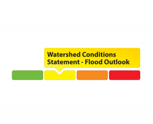
RVCA Watershed Conditions Statements:
- Water Safety – High flows, unstable banks, melting ice or other factors that could be dangerous for recreational users such as anglers, canoeists, hikers, children, pets, etc. Flooding is not expected.
- Flood Outlook – Early notice of the potential for flooding based on weather forecasts, calling for heavy rain, snow melt, high winds or other conditions that could lead to high runoff, cause ice jams and/or lakeshore flooding or erosion.
- Flood Watch – Flooding is possible in specific watercourses or municipalities. Municipalities, emergency services and individuals in flood prone areas should prepare.
- Flood Warning – Flooding is imminent or already occurring in specific watercourses or municipalities.
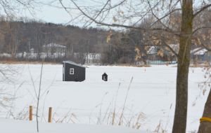
OTTAWA, March 1, 2021 – It’s officially March! And you know what that means: time to haul in your fishing huts, hockey nets and other gear before the ice is out.
Building materials, rink lights, benches and shovels, garbage and other waste can pollute our rivers and lakes, be toxic for fish and wildlife and create hazards for boaters and swimmers in the spring.
Under Ontario law, Eastern Ontario fishing huts must be removed by March 15. However, as the sun gets stronger and the weather begins to warm, it’s wise to remove them sooner rather than later. If you wait too long, you may find the ice too thin to access your belongings! It is an offence under the Public Lands Act to leave your ice hut out after ice break up, even if that occurs before the removal deadline.
So take some time this week to collect your belongings, dispose of your garbage and dismantle any structures you’ve built on the ice. Protect and respect the river that has kept you going all through the long winter months!
For complete fishing hut regulations visit www.ontario.ca/ice-fishing. To learn about water quality in your area and how to improve it, visit watersheds.rvca.ca.
-30-

WESTPORT, March 1, 2021 – Get out and enjoy everything winter has to offer with a free outdoor adventure kit from Foley Mountain Conservation Area.
Beginning March 2, families can pick up one of 100 kits from any Rideau Lakes or Westport library branch.
The kits include materials and instructions to identify and follow animal tracks in the snow, explore the wonderful world of snowflakes, do an experiment with a jello mouse, create a backyard birdfeeder, make snow ice cream and more.
“This is just another way we’re keeping connected with local families and promoting outdoor education,” said site supervisor Rebecca Whitman. “We hope people will be inspired to get outside more and enjoy all the fun winter has to offer.”
The kits were made possible through generous donations from Friends of Foley Mountain and the Township of Rideau Lakes, support from Kudrinko’s grocery store in Westport and distribution services from the libraries.
“This is the first time we’re doing this and we’re thrilled to have so many partners involved to keep families engaged while they’re at home,” Whitman said.
The kits can be adapted for all ages; parents can modify the activities as needed to engage both younger and older kids.
While signs of spring are starting to appear, there could still be another six weeks of winter – and this is the time when families start to feel the fatigue of the coldest months.
“I’m hoping these kits will help families pull through the last stretch of winter and keep the wonder of nature and the great outdoors at their fingertips,” Whitman said.
Questions about the kits can be sent to .
More “Fresh Air Fun” activities can be found at www.rvca.ca and on our YouTube channel.
-30-