
Super User
RVCA seeks public input for new hazard maps in North Gower
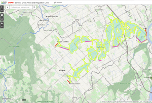
OTTAWA, November 23, 2021 — The Rideau Valley Conservation Authority (RVCA) is asking for public input on a new hazard mapping study for Stevens Creek in the City of Ottawa.
The study considers the risk of flooding, erosion and other hazards along Stevens Creek from Malakoff Road to the Rideau River. Members of the public are invited to review the draft regulation and hazard maps during a public consultation period between November 29, 2021 and January 13, 2022.
The new mapping shows areas that are subject to natural hazards such as flooding and unstable slopes, or that have natural environmental features such as wetlands. The mapping will be used by the City of Ottawa when updating its Official Plans and Zoning Schedules and in the review of development applications under the Planning Act. RVCA will also use the mapping to guide the review of development applications submitted under the RVCA’s Development, Interference with Wetlands and Alterations to Shorelines and Watercourses Regulation.
The goal of this mapping is to help ensure sound planning decisions are made — keeping people and property safe. Accurate engineered hazard mapping is the foundation of effective floodplain and resource management.
Members of the public are encouraged to review the draft mapping (available online at www.rvca.ca/stevens-creek) and connect with an RVCA Resource Specialist to understand how the mapping may affect their property. Due to COVID-19, we are not holding an in-person public open house. Instead, we invite you to contact an RVCA Resource Specialist via:
Individual or small group meetings on-line or in person can also be booked to discuss local impacts and concerns.
Conservation Authority staff also welcome local input on the mapping, including historical records of past flood events, slope failures, erosion, news clippings, photographs and even anecdotal stories to help confirm the reasonableness of calculations and resulting hazard mapping.
This study is just one of several ongoing hazard mapping studies taking place in the watershed. For a complete list of ongoing work, please visit www.rvca.ca. Learn more about the hazard mapping process in this short video:
RVCA seeks public input for new hazard maps in Beckwith Township
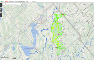
BECKWITH TOWNSHIP, Nov. 10, 2021 — The Rideau Valley Conservation Authority (RVCA) is asking for public input on a new hazard mapping study for the Jock River in Beckwith Township.
The study considers the risk of flooding, erosion and other hazards from Ashton Station Road to approximately the south limit of the community of Franktown. Members of the public are invited to review the draft regulation and hazard maps during the public consultation period between November 15 to December 22, 2021.
The new mapping shows areas that are subject to natural hazards such as flooding and unstable slopes or that have natural environmental features such as wetlands. The mapping will be used by Beckwith Township when updating its Official Plans and Zoning Schedules and in the review of development applications under the Planning Act. RVCA will also use the mapping to guide the review of development applications submitted under the RVCA’s Development, Interference with Wetlands and Alterations to Shorelines and Watercourses Regulation.
The goal of this mapping is to help ensure sound planning decisions are made — keeping people and property safe. Accurate engineered hazard mapping is the foundation of effective floodplain and resource management. This is the first time this section of the Jock River has been hazard mapped.
Members of the public are encouraged to review the draft mapping (available online at www.rvca.ca/upper-jock) and connect with an RVCA Resource specialist to understand how the mapping may affect their property. Due to COVID-19, we are not holding an in-person public open house. Instead, we invite you to contact an RVCA Resource Specialist via:
Individual or small group meetings on-line or in person can also be booked to discuss local impacts and concerns.
Conservation Authority staff also welcome local input on the mapping, including historical records of past flood events, slope failures, erosion, news clippings, photographs and even anecdotal stories to help confirm the reasonableness of calculations and resulting hazard mapping.
This study is just one of several ongoing hazard mapping studies taking place in the watershed. For a complete list of ongoing work, please visit www.rvca.ca. Learn more about the hazard mapping process in this short video:
Upper Jock River Hazard Mapping Study
Project Status: Complete
The Rideau Valley Conservation Authority (RVCA) has completed a hazard mapping study for the Jock River between Ashton Station Road and approximately the south limit of the community of Franktown. This section of the Jock River is being hazard mapped for the first time; however, both the Goodwood Marsh and Franktown Swamp (both Provincially Significant Wetlands and both within the study limits) have been regulated since 2006.
These maps have been traditionally known as “floodplain mapping” or “regulation mapping” and they show areas that are prone to natural hazards such as flooding, erosion and natural environment features such as wetlands.
When completed, the mapping will be used by Beckwith Township when updating their Official Plan and Zoning Schedules and in the review of development applications under the Planning Act. RVCA will also use the mapping to guide the review of development applications submitted under the Development, Interference with Wetlands and Alterations to Shorelines and Watercourses Regulation.
Due to Covid 19, we are not holding an in-person public open house. Instead, we invite you to contact an RVCA Resource Specialists at 613-692-3571 (toll-free 1-800-267-3504) extension 1193 or 1132 or . If you prefer, we can book individual or small group meetings on-line or in person to discuss local impacts and concerns. This is also an opportunity to learn how flood risks and slope stability hazards may affect shoreline management and/or development in Beckwith Township. Authority staff welcome historical records of past flood events, slope failure, erosion, news clippings, photographs and even anecdotal stories to help confirm the reasonableness of calculations and resulting hazard mapping.
This study is just one of several ongoing hazard mapping studies taking place in the watershed. For a complete list on ongoing work, click here.
Upper Jock Report
Report: Jock River Flood Risk Mapping from Richmond Road to Ashton Station Road, July 16, 2021
2021 Draft Maps
2021 Draft Maps
OPTION 1: Interactive Map - Click here to view the interactive map full screen
The interactive map allows you to zoom in to a specific property and get very specific digital informaiton. Need help? Have questions? Call a Resource Specialist at 613-692-3571 or 1-800-267-3504 ext. 1132 or 1193 or email us at .
OPTION 2: PDF Maps
If you prefer more traditional mapping, try our PDF maps. Need help? Have questions? Call a Resource Specialist at 613-692-3571 or 1-800-267-3504 ext. 1132 or 1193 or email us at .
|
Index Map:
|
Public Consultation
Members of the public are invited to review the draft regulation and hazard maps during the public consultation period between November 15 and December 22, 2021.
Questions? Comments? Please contact an RVCA Resource Specialist:
Phone: 613-692-3571 or 1-800-267-3504 ext. 1132 or 1193
Email: or complete an online property inquiry form
For those unable to participate in the consultation process, comments can be sent to Ferdous Ahmed, RVCA Senior Water Resources Engineer at .
Resources
- Upper Jock River Hazard Mapping Factsheet
- Video: Hazard Mapping for Floods: What it is and why we do it
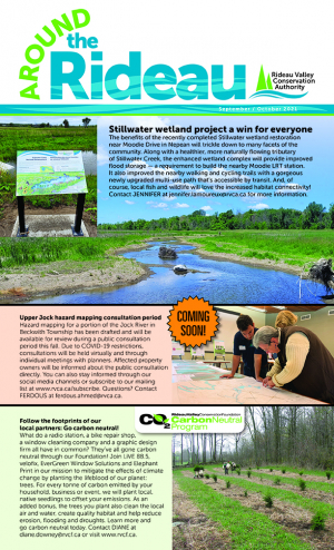
September-October 2021 Around the Rideau Newsletter now available!
Stillwater wetland project a win for everyone — The benefits of the recently completed Stillwater wetland restoration near Moodie Drive in Nepean will trickle down to many facets of the community. Want to read more? Click here.
If you enjoyed this story, why not read the rest of the Around the Rideau newsletter, or better yet, subscibe and the next edition will be waiting for you in your inbox! Subscribe here.
Green Acres tree planting program hits 2 million milestone
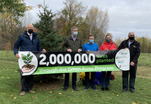
OTTAWA, Oct. 22, 2021 – The nation’s capital is now two million trees richer thanks to the City of Ottawa, local conservation authorities and rural landowners.
The City of Ottawa’s Green Acres Reforestation Program hit its two-million milestone this spring.
The program is a partnership between the City and its three local conservation authorities: Mississippi Valley Conservation Authority in the west, Rideau Valley Conservation Authority in central and south Ottawa and South Nation Conservation Authority in the east.
On Friday, Oct. 22 Mayor Jim Watson joined environment committee chair Coun. Scott Moffatt and other dignitaries to dedicate a white spruce at RVCA headquarters in honour of the milestone.
“Planting trees is one of the best ways to mitigate climate change and to protect our communities against extreme weather like floods,” said RVCA forestry manager Ian Cochrane. “We are incredibly thankful to the City and its rural landowners for their commitment to this program.”
The program generates huge benefits for the entire region. Along with creating the oxygen we need to breathe, trees also capture carbon, clean the air, create habitat and help reduce the impacts of floods, droughts and erosion.
The City provides annual base funding so the conservation authorities can work with willing landowners to create custom planting plans, order the seedlings and complete the planting each spring.
Landowners commit to reforesting at least 1.25 acres with a minimum of 1,000 trees. Conservation authority staff maintain the new trees for five years to maximize survival rates.
Green Acres has planted an average of 92,500 trees each year, with a target of 75,000 trees planted annually, primarily in the city’s four rural wards.
The top Ottawa wards for tree planting include:
- West Carleton-March (922,062 trees to date)
- Rideau-Goulbourn (569,536 trees to date)
- Cumberland (249,014 trees to date)
- Osgoode (220,110 trees to date)
- Plus 73,950 across the remaining Ottawa wards
While the 2022 program is already full, residents interested in reforesting their land are encouraged to visit ottawa.ca for more information or to contact their local conservation authority.
QUOTES:
“Forest growth and conservation has never been more vital. The work done through the Green Acres program by the City and its partners will play a huge role in combatting climate change and maintaining the beauty of our rural areas for generations to come.”
-Mayor Jim Watson
“The fact that the program is completely full until 2023 is a huge testament to our residents’ dedication to re-building Ottawa’s rural forests. I encourage all residents with empty land to consider applying for the Green Acres program and help us continue building on this milestone.”
-Councillor Scott Moffatt, Chair of the Standing Committee on Environmental Protection, Water and Waste Management
For more information contact RVCA Director of Communications Diane Downey at .
-30-
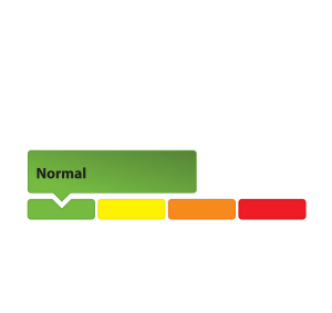
Low Water Status Returned to “Normal” in Rideau Valley Watershed
(WCS-LW - 5/2021)
October 6, 2021 – Watershed conditions in the Rideau Valley Watershed have returned to “Normal’ under the Ontario Low Water Response Program.
With above average rainfall amounts across the watershed over the last month, stream flows and water levels have recovered from the previous low water status and are now above average for this time of year.
Parks Canada continues to closely monitor the water levels throughout the Rideau Canal system inside the Rideau Valley watershed. Water levels in the reservoir lakes, located in the upper reaches of the Rideau Valley watershed, are now near normal for this time of year. Rideau River flows downstream of Big Rideau Lake remain at minimum value. Water levels in the Rideau River below Smiths Falls are within navigable ranges for this time of year.
Conservation Authority staff continue to monitor conditions and communicate with water managers throughout the watershed. Updates to this message will be issued as conditions warrant.
More resources:
- Ministry of Environment and Climate Change: https://www.ontario.ca/page/managing-your-water-well-times-water-shortage
- Ontario’s Low Water Response program: https://www.ontario.ca/page/low-water-response-program
- RVCA website: www.rvca.ca
- Hourly and daily streamflows and water levels: https://www.rvca.ca/watershed-monitoring-reporting/reporting/streamflow-water-levels
-end-
More Information:
Contact: Brian Stratton, RVCA Manager Engineering Services
Rideau Valley Conservation Authority
613-692-6804, 1-800-267-3504 ext. 1141
Rideau Valley Conservation Authority is a partnership of municipalities within the Rideau Valley watershed created under the Conservation Authorities Act to deliver a range of programs in watershed management and natural resource conservation.
RVCA Watershed Conditions Statements:
- Water Safety – High flows, unstable banks, melting ice or other factors that could be dangerous for recreational users such as anglers, canoeists, hikers, children, pets, etc. Flooding is not expected.
- Flood Outlook – Early notice of the potential for flooding based on weather forecasts, calling for heavy rain, snow melt, high winds or other conditions that could lead to high runoff, cause ice jams and/or lakeshore flooding or erosion.
- Flood Watch – Flooding is possible in specific watercourses or municipalities. Municipalities, emergency services and individuals in flood prone areas should prepare.
- Flood Warning – Flooding is imminent or already occurring in specific watercourses or municipalities.
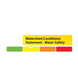
(WCS – R05/2021)
September 22, 2021 – Environment Canada is forecasting rainfall amounts of 60 to 90 mm starting today through early Friday morning, with a few localities possibly exceeding 100 mm. The higher amounts are forecasted for the upper part of the Rideau Valley Watershed. This widespread rainfall event is due to a cold front and a moisture-laden low pressure system that will arrive from the American Midwest.
Because the Rideau Valley Watershed is currently in a ‘minor low water condition,’ all water levels and flows are currently below normal, so significant flooding is not expected. However, this large rain event will cause all water levels and flows to increase rapidly and could cause localized flooding in small watercourses, urban areas and ditches.
The RVCA reminds the public to exercise extreme caution around all waterbodies and remind children about the dangers of playing near open water. Residents are reminded to make sure their sump pumps are in good working condition and to help reduce ponding by keeping ditches, culverts, and storm drains clear of obstructions.
This watershed conditions statement is in effect until Tuesday, September 28, 2021 at 5 PM or until an update has been issued.
-end-
More Information:
Contact: Brian Stratton, RVCA Manager Engineering Services
Rideau Valley Conservation Authority
613-692-6804, 1-800-267-3504 ext. 1141
Rideau Valley Conservation Authority is a partnership of municipalities within the Rideau Valley watershed created under the Conservation Authorities Act to deliver a range of programs in watershed management and natural resource conservation.
RVCA Watershed Conditions Statements:
- Water Safety – High flows, unstable banks, melting ice or other factors that could be dangerous for recreational users such as anglers, canoeists, hikers, children, pets, etc. Flooding is not expected.
- Flood Outlook – Early notice of the potential for flooding based on weather forecasts, calling for heavy rain, snow melt, high winds or other conditions that could lead to high runoff, cause ice jams and/or lakeshore flooding or erosion.
- Flood Watch – Flooding is possible in specific watercourses or municipalities. Municipalities, emergency services and individuals in flood prone areas should prepare.
- Flood Warning – Flooding is imminent or already occurring in specific watercourses or municipalities.
Plan ahead to avoid fall colour crowds at Foley Mountain
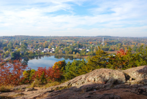
WESTPORT, Sept. 22, 2021 – Foley Mountain’s Spy Rock lookout is a popular fall destination at the best of times, but this year staff are preparing for record crowds as pandemic-weary residents search for safe ways to enjoy the season’s splendour.
Staff will be monitoring the volume of cars at peak times and turning vehicles away if necessary to manage crowds and line-ups. Spy Rock lookout will be limited to 25 people at a time, and visitors will be encouraged to use auxiliary parking at the Interpretive Centre and other areas of the park to ease congestion.
Site supervisor Rebecca Whitman said Thanksgiving weekend is the busiest time of the year, with weekends on either side of the holiday also attracting large crowds.
She said guests can help ensure their visit goes smoothly by following these tips:
- Arrive during off-peak times (ex. early morning, mid-week)
- Bring coins instead of credit cards for the pay machine, or use PayByPhone.com (location code 5204)
- Be prepared to hike to the lookout from auxiliary parking
- Have a backup plan if you’re turned away, especially if you’re coming from out of town
- Pack a picnic and enjoy other parts of the park, not just the lookout (read up on three alternative fall hikes here: https://www.rvca.ca/view-all-blog-posts/beyond-spy-rock-three-fabulous-fall-hikes-at-foley-mountain)
- Bring a mask for crowded areas and stay home if you’re feeling unwell.
For fall colour maps and park information visit www.rvca.ca/foley-fall-colours. For the most up-to-date information follow our Facebook pages at @FoleyMountain and @RideauValleyConservationAuthority or follow RVCA on Twitter at @RideauValleyCA.
You can also contact with specific questions.
-30-
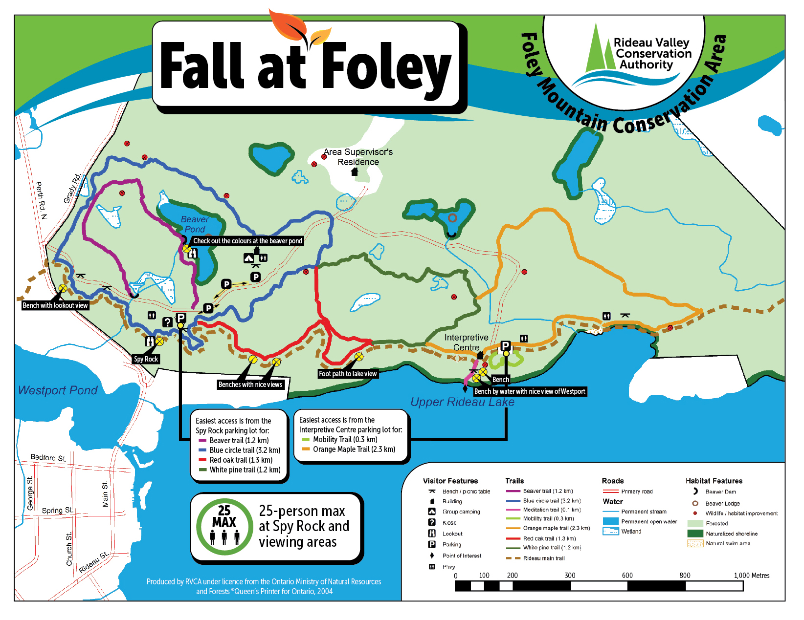
Foley Fall Colours

Fall Colours at Foley Mountain, 2023
Foley Mountain is spectacular in fall, but visitors should plan ahead to avoid crowds.
During the peak season (end of September to mid-October), staff will be on-site to assist visitors with purchasing passes, managing parking, and helping things run smoothly. Visitors may be asked to park in auxiliary parking at the Interpretive Centre and other areas away from Spy Rock to ease congestion.
See the Foley Fall Colours map for alternative parking and trail directions (click map to download a PDF):
To ensure a safe and enjoyable visit, follow these tips:
AVOID PEAK TIMES:
Thanksgiving weekend is the busiest time of the year at Foley Mountain, with weekends on either side of the holiday also attracting large crowds. Avoid line-ups and crowds by visiting at off-peak times, such as early in the morning or in the evening, and mid-week instead of weekends.
PARKING:
The Spy Rock parking lot fills up quickly, especially on weekends. Come prepared with coins instead of credit cards for the pay machine, or use www.PayByPhone.com to reduce long line-ups (location code 5204).
You may also be asked to park in auxiliary parking areas at the Interpretive Centre, group camping site or at designated spots along the main road to reduce congestion. Be prepared to hike a short distance back to Spy Rock, either along the road or using one of the park’s other trails.
SPY ROCK:
As one of the most popular lookouts at Foley Mountain, Spy Rock can be a busy spot during fall colours. Please be considerate of other visitors and resist the temptation to linger a long time when others are waiting. Take your time to enjoy the view and take some photos, and then let others have a chance!
EXPLORE THE PARK:
There’s more to Foley Mountain than Spy Rock: explore it! Check out this blog outlining three alternative fall hikes to try: https://www.rvca.ca/view-all-blog-posts/beyond-spy-rock-three-fabulous-fall-hikes-at-foley-mountain
STAY INFORMED:
For maps and general park information visit www.rvca.ca/conservation-areas/fee-required/foley-mountain-ca. For the most up-to-date information follow our Facebook pages at @FoleyMountain and @RideauValleyConservationAuthority or follow RVCA on Twitter at @RideauValleyCA.