
Super User
PORTLAND, July 18, 2022 – The village of Portland has been invaded by a new type of yellow fish – but this species is here to help.
The Yellow Fish Road project is just one aspect of a larger sustainable drainage pilot program kicking off this summer, thanks to funding from the Township of Rideau Lakes and support from the Big Rideau Lake Association and Cataraqui Region Conservation Authority. The freshly painted roadside fish are meant to remind residents that storm drains are directly connected to our local lakes, rivers and streams – and that chemicals, fertilizers and feces should be kept well away for the health of the water and the community.
This summer, staff from the Rideau Valley Conservation Authority (RVCA) are investigating novel ways to divert and capture runoff to reduce nutrients reaching Big Rideau Lake. These nutrients – which are washed into the water system as lawn fertilizers, detergents, septic system leaks and more – can cause excessive aquatic weed growth, contribute to harmful blue-green algae blooms and reduce overall water quality.
The project’s goal is to recommend the best sustainable drainage techniques and practices available to help the Township of Rideau Lakes protect water quality for the entire community.
RVCA staff will sample and monitor an urban catchment drain in the village of Portland and a rural non-agricultural drain just outside the village. Staff will also research best practices for sustainable drainage and implement some new practices this fall in an effort to reduce local runoff.
“Our hope is to implement a few demonstration sites around town to really inspire people to get involved,” said Mike Yee, co-project manager, aquatic biologist and planner with the RVCA. “We want to raise awareness among residents that a few simple actions can protect their lake for the long term.”
Many established sustainable drainage practices are easy and cost-effective for residents to embrace right now, Yee said. These include installing a rain barrel, planting a rain garden, moving downspouts to a permeable area and adding native plants to shorelines and ditches.
“If everyone does a little, we can accomplish a lot,” Yee said.
To learn more about sustainable drainage and for practical guides to implementing best practices, visit https://www.rvca.ca/sustainable-drainage-pilot-project-portland.
For more information contact or .
-30-
Sustainable Drainage Pilot Project (Portland)
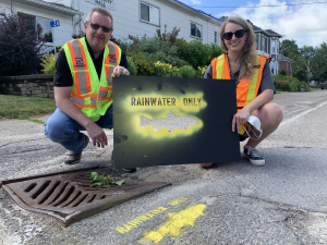
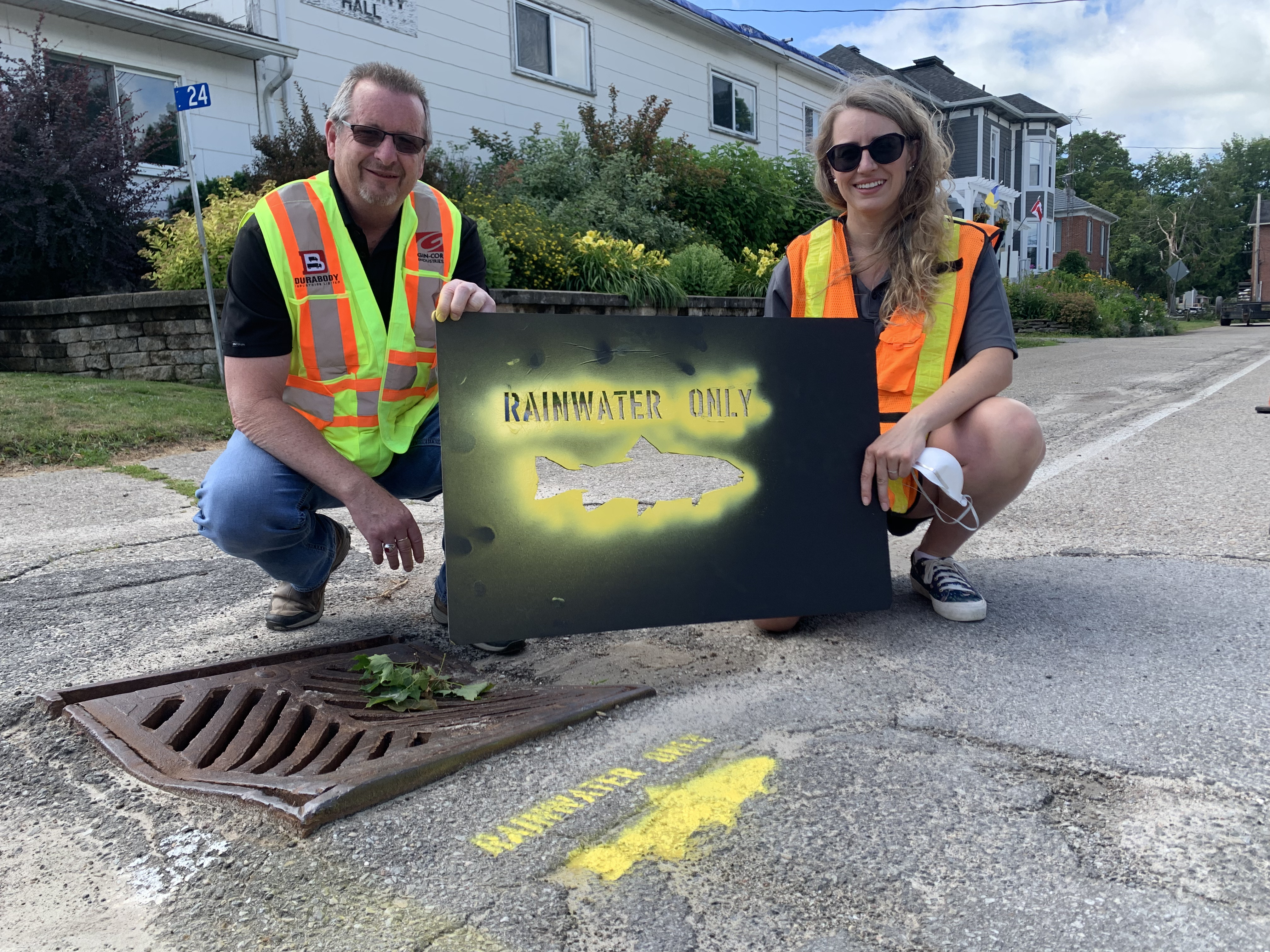 Township of Rideau Lakes drainage manager Dan Chant joined RVCA intern Caitlin Sommer in Portland this July to paint yellow fish on several storm drains. These fish will remind residents that stormwater goes directly to the lake.The Township of Rideau Lakes has generously funded a pilot partnership with Big Rideau Lake Association, Cataraqui Region Conservation Authority and Rideau Valley Conservation Authority to work co-operatively on a sustainable drainage pilot project in the village of Portland and the surrounding rural catchment area.
As climate change contributes to more frequent and extreme rain events, excess nutrients, sediments, harmful chemicals and pollutants are increasingly washed into Big Rideau Lake through our storm drainage systems. This contributes to increased aquatic weed growth, more toxic algae blooms and an overall decline in lake health and enjoyment.
In summer 2022, staff from RVCA as well as volunteers from the Big Rideau Lake Association conducted a sampling and monitoring program, targeting an urban drain in the village as well as a rural drain (non-agricultural) outside the village. Research was conducted to find and recommend sustainable drainage practices that are best suited to protect water quality and lake health.
Read the Monitoring Report/Summary.
Read the final Recommendations Report.
Resources:
Reducing your runoff can also begin at home – and can be as easy as installing a rain barrel. To learn more about how you can reduce stormwater runoff on your own property, check out the resources below.
VIDEO: Learn how to build a low-cost, low-maintenance rain garden on your property: https://youtu.be/dvgJXlul9Bk
VIDEO: Learn how the RVCA’s Shoreline Naturalization Program offers technical and financial support for waterfront owners to naturally reduce their runoff: https://youtu.be/j2WEnMfRZTo
BLOG: Learn all the simple, cost-effective ways you can reduce runoff on your own property: https://www.rvca.ca/view-all-blog-posts/soak-up-the-summer-storms-reducing-your-runoff-in-the-big-city
BLOG: Learn more about the RVCA’s Clean Water Grants program that supports sustainable drainage and other projects for rural residents: https://www.rvca.ca/view-all-blog-posts/grant-program-makes-clean-water-projects-affordable
INTERACTIVE: Scroll over the pins to learn how you can keep contaminants out of your storm drain: https://www.rvca.ca/view-all-blog-posts/reducing-runoff-which-side-are-you-on
INTERACTIVE: Check out this interactive graphic for sustainable drainage practices on waterfront properties: https://www.rvca.ca/view-all-blog-posts/waterfront-living-which-side-are-you-on
WEBPAGE: Learn more about how to naturalize your shoreline (whether it’s a ditch, stream, river or lake!): https://www.rvca.ca/stewardship-grants/shoreline-naturalization/how-to-naturalize-your-shoreline
Benefits of sustainable drainage:
- Reduced algae blooms and excessive weed growth in our lakes and rivers
- Improved water quality for local ecosystems
- Better water quality for local tourist industries including recreational fishing and seasonal rentals
- Safer drinking water for residents with surface water intakes
- Improved knowledge of sustainable drainage best practices can be applied across the watershed
More Information:
Septic Approvals
![]()
![]()
The Mississippi Valley and Rideau Valley Conservation Authorities administer Part 8 (Sewage systems approvals) of the Ontario Building Code on behalf of several watershed municipalities (listed below). This means your local conservation authority is responsible for reviewing septic designs and plans, issuing Building Permits for new and replacement sewage systems, and inspecting installations to ensure compliance with provincial regulations.
Learn more on how to submit your application by choosing the municipality where you are installing or replacing a Part 8 sewage system. Not listed below? Check with your municipality to learn about their septic approvals agent.
Who should you call for septic information?
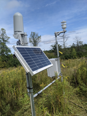
RIDEAU VALLEY, June 10, 2022 – A new network of industrial weather stations will advance the Rideau Valley Conservation Authority’s capacity to track local weather, model future floods and track local climate change impacts into the future.
The RVCA has installed 11 new all-season weather stations across the watershed. These will fill gaps in the current data network, expand RVCA’s list of tracked weather parameters and provide real-time weather data online for use by residents, municipalities, farmers, researchers and even local forecasters.
“Our goal is to develop a watershed-wide model so we understand what’s happening in each part of the watershed,” said Brian Stratton, RVCA’s manager of engineering. “The new weather stations are a key piece in the development of a long-term model that can be used for hazard mapping, flood forecasting and tracking climate change trends.”
The industrial-strength stations – designed to withstand our coldest winters and hottest summers – will collect information on air temperature, dew point, relative humidity, air pressure, solar radiation, average wind speed and precipitation. The data is available through a new public portal on www.rvca.ca/weather-stations.
The addition of these stations will also improve Environment Canada’s ability to provide accurate weather forecasting for the region, as data from RVCA’s new stations will help corroborate what Environment Canada’s radar is predicting.
“It’s a nice relationship,” said RVCA’s hydrometric co-ordinator Justin Robert. “We’ve programmed these stations for our own purposes, but everyone in the watershed will benefit.”
Climate researchers will also rejoice – in 30 years, anyway.
“By recording the real time climate, it’s going to set us up for some extensive knowledge down the road,” Robert said. “These weather stations are going to give us this footprint of our weather into our future, and it will be invaluable information to really understand our watershed and what’s going on.”
To learn more about the RVCA's Flood Forecasting and Warning program, visit www.rvca.ca/watershed-conditions.
New weather stations are located in: Andrewsville, Bobs Lake, Frankville, Kars, Mansfield, Marlborough, Montague, Motts Mills, Rainbow Lake, Snowdons Corners and Westport. For more information contact Brian Stratton at .
-30-
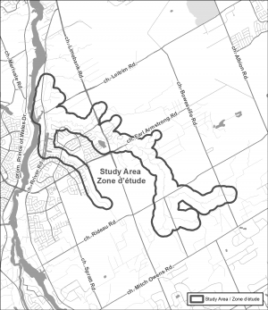
OTTAWA, June 7, 2022 — The Rideau Valley Conservation Authority (RVCA) has completed a hazard mapping study for Mosquito Creek from Mitch Owens Road to the Rideau River, in and around the community of Riverside South. Members of the public are invited to an upcoming open house to review regulation and hazard maps.
Much of the area has been regulated since 2017 when hazard mapping was completed for the Rideau River from Hogs Back to Kars (Rideau River Flood Risk Mapping Report from Hogs Back to Kars, July 2017). This 2017 mapping captured Mosquito Creek from the Rideau River to Limebank Road. This new study reviews past mapping and extends upstream from Limebank Road to Mitch Owens.
The new mapping shows areas that are subject to natural hazards such as flooding and unstable slopes and have natural environmental features such as wetlands. The mapping will be used by the City of Ottawa when updating Official Plans and Zoning Schedules and in the review of development applications under the Planning Act. RVCA will also use the mapping to guide the review of development applications submitted under the RVCA’s Development, Interference with Wetlands and Alterations to Shorelines and Watercourses Regulation.
The goal of this mapping is to help ensure that sound planning decisions are made — keeping people and property safe. Accurate engineered hazard mapping is the foundation of effective floodplain and resource management.
Members of the public are encouraged to attend the open house and/or provide comments on the mapping. The RVCA also welcomes every bit of information that we can obtain about the historical behaviour of local watercourses. Residents and landowners living along these features may have anecdotal or documented information such as photographs or journal entries of their observations during past high-water events or slope failures.
Mosquito Creek Hazard Land and Regulations Mapping Public Open House
Rideauview Community Centre
4310 Shoreline Drive, Ottawa
Tuesday, June 28, 2022
4:30 to 8:00 p.m.
For those unable to attend the open house, mapping can also be seen online at www.rvca.ca/mosquito-creek. Individual or small group meetings (on-line or in-person) can also be booked by contacting an RVCA Resource Specialist at or by completing an online property inquiry form at www.rvca.ca/regulations-planning/general-property-inquiries.
The public consultation period will run until July 29, 2022.
This study is being done through a collaboration involving the City of Ottawa and the Rideau Valley, Mississippi Valley and South Nation Conservation Authorities. The City recognized a need to update its zoning schedules based on up-to-date hazard mapping and has provided contributions enabling the Conservation Authorities to move ahead with these studies sooner than would otherwise be possible. The RVCA is currently working on several studies in the Ottawa area. For a complete list of ongoing work, please visit www.rvca.ca.
— end —

RIDEAU VALLEY, June 1, 2022 – No cell service? No problem! Visitors to RVCA’s conservation areas can now navigate even our most remote trails with confidence thanks to a new partnership with Avenza Maps.
The Toronto-based mobile app offers GPS-enabled maps that can be used offline and without cell service to keep your bearings even in the deepest woods.
“Safety is number one, and this is an innovative tool to help our visitors stay on track while exploring our beautiful properties,” said Conservation Lands Manager Chelsey Ellis. “We’re pleased to partner with such an ambitious and community-oriented organization.”
Tristan Lyttle, senior product manager with Avenza Systems Inc., agreed.
“We’re thrilled to see our local conservation authorities become early adopters of this technology,” Lyttle said. “Getting outside and exploring our surroundings has never been more important, and Avenza makes it even easier.”
The app is supported by Android and iOS. Instructions on how to get started and use the mobile app can be found at https://www.avenzamaps.com/maps/how-it-works.html. QR codes for the RVCA’s new Avenza maps have been installed at the trailheads of eight conservation areas, and can also be found on their property-specific webpages at www.rvca.ca/conservation-areas. Scanning these QR codes will download RVCA’s maps to your phone to take out onto the trail. Ifyou don't have Avenza Maps app, you will be guided through the installation process
To avoid installation issues, the RVCA encourages visitors to download the free app before leaving home. Traditional trailhead maps and printed brochures will continue to be available, as well as downloadable PDF maps on the RVCA website.
The RVCA offers a total of 42 km of trails through forests, wetlands, meadows and more. From the Chapman Mills boardwalk in Barrhaven to the Spy Rock lookout at Foley Mountain, our 11 conservation areas offer something for everyone, all year round.
For more information visit www.rvca.ca/conservation-areas or contact Conservation Lands Manager Chelsey Ellis at .
-30-
Mosquito Creek Hazard Mapping Study
Project Status: Complete
 The Rideau Valley Conservation Authority (RVCA) has completed a hazard mapping study for Mosquito Creek from Mitch Owens Road to the Rideau River in the City of Ottawa.
Much of the area has been regulated since 2017 with the completion of the report entitled: Rideau River Flood Risk Mapping from Hogs Back to Kars, July 2017. This 2017 mapping captured Mosquito Creek from the Rideau River to Limebank Road. This new study extends to Mitch Owens and will update previous mapping.
These maps have been traditionally known as “floodplain mapping” or “regulation mapping” and they show areas that are prone to natural hazards such as flooding, erosion and natural environment features such as wetlands.
When completed, the mapping will be used by the City of Ottawa when updating their Official Plan and Zoning Schedules and in the review of development applications under the Planning Act. RVCA will also use the mapping to guide the review of development applications submitted under the Development, Interference with Wetlands and Alterations to Shorelines and Watercourses Regulation.
Members of the public are invited to share information and review the draft regulation and hazard maps (available below) during the public consultation period which will run until July 29, 2022. We also welcome you to see the draft hazard and regulations maps at the public open house.
Mosquito Creek Hazard Land and Regulations Mapping Open House
Rideauview Community Centre
4310 Shoreline Drive, Ottawa
Tuesday, June 28, 2022
4:30 to 8:00 p.m.
You can also book individual or small group meetings on-line or in person to review mapping and discuss potential impacts and concerns by contacting an RVCA Resource at 613-692-3571, toll-free at 1-800-267-3504 or by email at or complete an online property inquiry form.
This study is just one of several ongoing hazard mapping studies taking place in the watershed. For a complete list on ongoing work, click here.
Draft Maps
OPTION 1: Interactive Map - Click here to view the interactive map full screen
The interactive map allows you to zoom in to a specific property and get very specific digital informaiton. Need help? Have questions? Call a Resource Specialist at 613-692-3571 or 1-800-267-3504 ext. 1132 or 1193 or email us at .
OPTION 2: PDF Maps
If you prefer more traditional mapping, try our PDF maps accessible below. Need help? Have questions? Call a Resource Specialist at 613-692-3571 or 1-800-267-3504 ext. 1132 or 1193 or email us at .
|
Index Map:
|
Resources
- Landowner Factsheet: Moquito Creek Hazard Mapping
- Fiche descriptive : Étude cartographique des risques liés au ruisseau Mosquito
- Video: Hazard Mapping for Floods: What it is and why we do it
Monitoring & Reporting - copy 2022
The RVCA collects, monitors and analyses watershed information.
Monitoring environmental conditions helps us see trends over time, focus our actions where they can do the most good, and evaluate the effectiveness of our watershed policies and programs.
Reporting information ensures the right information is available to municipal and watershed decision makers (including watershed residents).
Use the menu to the right to visit our monitoring and reporting information. You can also access information through our interactive mapping. See below for details on what is currently available.
Interactive Mapping Tool
Access information through our interactive mapping tool. Choose from these mapping options:
|
|
|
|
||
| Access our robust interactive mapping with multiple tools to help you find regulation limits, flood event depths, flood & low water status, landcover, conservation areas and more. |
See real-time and periodic information from a network of sources from across the watershed. |
View water quality data collected across the watershed. See where we test and the results. | Explore our subwatershed reports that highlight four indicators of watershed health: water quality, forest cover, wetland cover and riparian cover. | Search properties to see if it may be subject to Section 28 — Ontario Regulation 174/06 (Development, Interference with Wetlands and Alternations to Shorelines and Watercourses Regulation. |
LANARK COUNTY, May 13, 2022 – Lanark farmers can access even more stewardship grant options thanks to a new partnership with agricultural stewardship organization, ALUS.
The new ALUS community, called ALUS Lanark, will facilitate new grassroots, farmer-led natural infrastructure projects in Lanark County, and will be administered by staff at the Rideau Valley Conservation Authority (RVCA) and the Mississippi Valley Conservation Authority (MVCA).
While the RVCA currently offers a rural clean water stewardship program on behalf of both conservation authorities, this new partnership will expand the number of opportunities available in Lanark, specifically for agricultural properties.
“We’re thrilled to partner with ALUS to expand our stewardship programs for farmers in Lanark County,” says Sommer Casgrain-Robertson, General Manager, RVCA. “We know many Lanark farmers want to enhance their operations for the health of their lands, livestock and the watershed, and this partnership will support them in those efforts and give them even more opportunities to do that.”
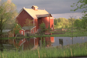
Home to approximately 60,000 people, the county is a picturesque rural landscape of forests, lakes, wetlands, agriculture, cottages and small towns. The county also has the Rideau River and the Mississippi River passing through it and contains parts of the Canadian shield and the Great Lakes basin, important and unique natural features.
"Our county is focused on local climate change solutions," says John Fenik, Lanark County Warden. "Supporting farmers in their efforts to improve biodiversity and water quality on their lands is an important part of this strategy and is why we are so excited to partner with our local conservation authorities to bring the ALUS program to Lanark."
The new program will support farmers in the creation of an array of ecosystem projects, including reforestation, windbreaks, riparian buffers, wetland projects, tallgrass prairie, pollinator habitat and more.
“Our partnership with the County, ALUS and RVCA is a win for Lanark farmers, the community and the Mississippi watershed,” says Sally McIntyre, General Manager, Mississippi Valley Conservation Authority. “Farmers are frontline stewards of the land, and this program will help them to adapt to changing economic and climatic conditions.”
These projects will contribute to the health of the farmers’ privately-owned landscape, while also benefitting the broader environment by providing support for biodiversity; reducing downstream flooding in neighbouring communities and ecosystems; and mitigating the impacts of climate change through carbon sequestration and other natural mechanisms.
“ALUS is so happy to be adding another community in Ontario,” says Alyssa Cousineau, Eastern Hub Manager, ALUS. “It’s clearer each passing year how important a healthy environment is for communities to thrive, which is why we are thrilled to see new communities adopt the ALUS model to help enrich the natural world that we all depend on.”
ALUS Lanark will be guided in its decision making by a Partnership Advisory Committee (PAC). The PAC ensures that local priorities are addressed by ALUS projects. Fifty per cent of the committee members are local farmers who, in partnership with the other committee members (local elected officials, environmental experts, etc.), will determine which projects are prioritized for the ALUS program.
About ALUS
ALUS (originally an acronym for Alternative Land Use Services) is a charitable organization that sustains agriculture and biodiversity for the benefit of communities and future generations. ALUS provides direct financial and technical support to a network of more than a thousand farmers and ranchers who deliver ecosystem services in more than 30 communities across Canada, such as cleaner air, cleaner water, carbon sequestration, erosion control, flood mitigation, pollinator support and wildlife habitat. Learn more at ALUS.ca.
-30-